IMAGES TAKEN NEAR TO
Milton, MARTOCK, TA12 6AL
Introduction
This page details the photographs taken nearby to TA12 6AL by members of the Geograph project.
The Geograph project started in 2005 with the aim of publishing, organising and preserving representative images for every square kilometre of Great Britain, Ireland and the Isle of Man.

There are currently over 7.5m images from over14,400 individuals and you can help contribute to the project by visiting https://www.geograph.org.uk
Image Map (Loading...)


Getting Data...Please wait
Leaflet Map data © OpenStreetMap
Images are licensed for reuse under creativecommons.org/licenses/by-sa/2.0
Notes
- Clicking on the map will re-center to the selected point.
- The higher the marker number, the further away the image location is from the centre of the postcode.
Image Listing (7 Images Found)
Images are licensed for reuse under creativecommons.org/licenses/by-sa/2.0
Image
Details
Distance
1
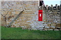
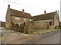
Victorian letter Box, Milton
This old letter box is in a boundary wall adjacent to a barn on the edge of a farmyard on the main street of this tiny hamlet.
Image: © Nigel Mykura
Taken: 28 Dec 2016
0.03 miles
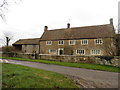
2
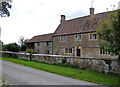
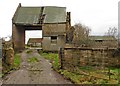
Manor Farm House
A substantial stone building in need of some TLC.
Image: © Jonathan Billinger
Taken: 13 Aug 2007
0.08 miles
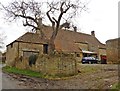
7

Countryside near Milton
View south across the levels from the minor road that runs from near Stapleton Cross north to Milton.
Image: © Nigel Mykura
Taken: 23 Jan 2011
0.21 miles