IMAGES TAKEN NEAR TO
Witcombe Lane, MARTOCK, TA12 6AH
Introduction
This page details the photographs taken nearby to Witcombe Lane, TA12 6AH by members of the Geograph project.
The Geograph project started in 2005 with the aim of publishing, organising and preserving representative images for every square kilometre of Great Britain, Ireland and the Isle of Man.

There are currently over 7.5m images from over14,400 individuals and you can help contribute to the project by visiting https://www.geograph.org.uk
Image Map
Images are licensed for reuse under creativecommons.org/licenses/by-sa/2.0
Notes
- Clicking on the map will re-center to the selected point.
- The higher the marker number, the further away the image location is from the centre of the postcode.
Image Listing (18 Images Found)
Images are licensed for reuse under creativecommons.org/licenses/by-sa/2.0
Image
Details
Distance
2
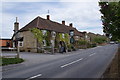
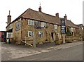
The Bell Inn at Ash
A view of the pub looking east along Main Street.
Image: © Andy Pearce
Taken: 1 May 2009
0.09 miles
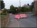
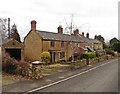
3
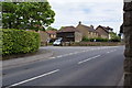
Junction of Witcombe Lane and Main Street, Ash
Witcombe Lane going off to the left to the hamlet of Witcombe.
Image: © Andy Pearce
Taken: 1 May 2009
0.11 miles
10
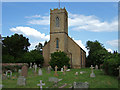
Holy Trinity Church - Ash
Completed by Kempthorne in 1840, with the addition of the west tower during the 2oth century.
Image: © Mike Searle
Taken: 5 Jun 2007
0.16 miles