IMAGES TAKEN NEAR TO
Canal Road, TAUNTON, TA1 1PH
Introduction
This page details the photographs taken nearby to Canal Road, TA1 1PH by members of the Geograph project.
The Geograph project started in 2005 with the aim of publishing, organising and preserving representative images for every square kilometre of Great Britain, Ireland and the Isle of Man.

There are currently over 7.5m images from over14,400 individuals and you can help contribute to the project by visiting https://www.geograph.org.uk
Image Map
Images are licensed for reuse under creativecommons.org/licenses/by-sa/2.0
Notes
- Clicking on the map will re-center to the selected point.
- The higher the marker number, the further away the image location is from the centre of the postcode.
Image Listing (502 Images Found)
Images are licensed for reuse under creativecommons.org/licenses/by-sa/2.0
Image
Details
Distance
1
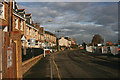
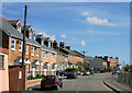
Prospect Terrace, Taunton
35 metre long row of houses set back from the north side of Canal Road.
Image: © Jaggery
Taken: 16 Dec 2014
0.00 miles
3
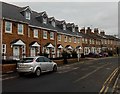
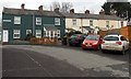
Market Terrace and Canal Terrace, Taunton
Viewed across Canal Road. Newer houses in Market Terrace in the foreground,
older houses in Canal Terrace in the background.
Image: © Jaggery
Taken: 16 Dec 2014
0.03 miles
5
Fire Pool Lock construction site, Taunton
Viewed in mid December 2014. The Firepool (or Fire Pool) project is one of the largest mixed-use regeneration schemes in the South West of England. The left turn is for the south side of Taunton Railway Station.
Image: © Jaggery
Taken: 16 Dec 2014
0.04 miles
6
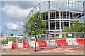
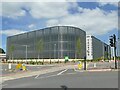
Taunton : Construction Site
Looking towards an under construction car park.
Image: © Lewis Clarke
Taken: 1 Aug 2020
0.04 miles
7
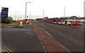
Strictly no parking in this part of Canal Road, Taunton
The area is alongside the perimeter fence of the site of the demolished livestock market.
Premier Parking Solutions warning notices state that this land is private property -
STRICTLY NO PARKING AT ANY TIME. Any vehicles found parked here contravening the above or any other conditions advertised across this site are contractually agreeing to pay a parking charge to the sum of £100 reduced to £60 if paid within 14 days. Conditions apply 24 hours a day, 7 days a week.
A Google Earth Street View taken six months earlier, before the notices were installed, shows a dozen vehicles parked here...
Image: © Jaggery
Taken: 16 Dec 2014
0.04 miles
8
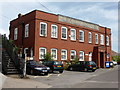
GWR Goods Office - Taunton
A fine railway building proclaiming its provenance and purpose.
Image: © Chris Allen
Taken: 12 Jul 2014
0.05 miles
9
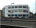
Art Deco building at Taunton
This building is called Hi-Point and it houses a few businesses. It is positioned in Thomas Street. Taken from the railway platform at Taunton.
Image: © paul dickson
Taken: 24 May 2008
0.05 miles
10
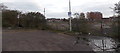
GWR Taunton, Trenchard Way
Trenchard Way, the A3087, is a recent inner bypass road and named after Hugh Trenchard, founder of the RAF at the end of World War I, who came from Taunton. This stretch of it is on former railway land outside the town's station. The building on the left is partly car park, partly offices.
Image: © Stephen Craven
Taken: 14 Jul 2021
0.05 miles