IMAGES TAKEN NEAR TO
St. James Street, TAUNTON, TA1 1JR
Introduction
This page details the photographs taken nearby to St. James Street, TA1 1JR by members of the Geograph project.
The Geograph project started in 2005 with the aim of publishing, organising and preserving representative images for every square kilometre of Great Britain, Ireland and the Isle of Man.

There are currently over 7.5m images from over14,400 individuals and you can help contribute to the project by visiting https://www.geograph.org.uk
Image Map (Loading...)


Getting Data...Please wait
Leaflet Map data © OpenStreetMap
Images are licensed for reuse under creativecommons.org/licenses/by-sa/2.0
Notes
- Clicking on the map will re-center to the selected point.
- The higher the marker number, the further away the image location is from the centre of the postcode.
Image Listing (691 Images Found)
Images are licensed for reuse under creativecommons.org/licenses/by-sa/2.0
Image
Details
Distance
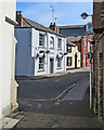
1
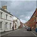
Taunton: Lower Middle Street
A view towards St James Street.
Image: © John Sutton
Taken: 14 Jun 2015
0.01 miles
2
Taunton: on Lower Middle Street
I was drawn by the rusty corrugated-iron roof and leaning walls of the little shop on the right.
Image: © John Sutton
Taken: 26 Jun 2023
0.01 miles

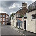
4

Courtyard cafe, Taunton
This courtyard is between St James Street and Middle Street, accessed by passage ways from each street.
Image: © John C
Taken: 26 Jun 2019
0.02 miles
5
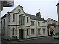
Somerset House
This imposing white building is located at the corner of Lower Middle Street and Whirligig Lane.
Image: © Ruth Riddle
Taken: 18 Feb 2011
0.02 miles
6
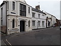
Lower Middle Street, Taunton
The white building are the offices of Reed Holland Associates Ltd Architects & Interior Designers who give their address as Middle Street. The street names shown on the wall show Lower Middle Street. The street name from where the photograph was taken shows Middle Street.
Image: © John C
Taken: 26 Jun 2019
0.02 miles
7
Taunton: Middle Street and The Bank
A very good place to eat, seen from Whirligig Lane.
Image: © John Sutton
Taken: 13 Jun 2017
0.02 miles
8
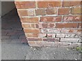
Ordnance Survey Cut Mark
This OS cut mark can be found on a building NE side of Middle Street. It marks a point 16.652m above mean sea level.
Image: © Adrian Dust
Taken: 12 Jul 2023
0.02 miles
9
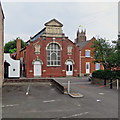
Taunton: former YMCA Gymnasium
The tower of St James's Church shows in the distance.
Image: © John Sutton
Taken: 10 Jun 2018
0.02 miles
10
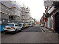
Taunton : St James Street
Looking along the road.
Image: © Lewis Clarke
Taken: 18 Jan 2021
0.02 miles