IMAGES TAKEN NEAR TO
Coal Orchard, TAUNTON, TA1 1FE
Introduction
This page details the photographs taken nearby to Coal Orchard, TA1 1FE by members of the Geograph project.
The Geograph project started in 2005 with the aim of publishing, organising and preserving representative images for every square kilometre of Great Britain, Ireland and the Isle of Man.

There are currently over 7.5m images from over14,400 individuals and you can help contribute to the project by visiting https://www.geograph.org.uk
Image Map (Loading...)


Getting Data...Please wait
Leaflet Map data © OpenStreetMap
Images are licensed for reuse under creativecommons.org/licenses/by-sa/2.0
Notes
- Clicking on the map will re-center to the selected point.
- The higher the marker number, the further away the image location is from the centre of the postcode.
Image Listing (678 Images Found)
Images are licensed for reuse under creativecommons.org/licenses/by-sa/2.0
Image
Details
Distance
1
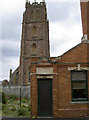
Side door
An older entrance to the Ring of Bells. Once this pub was at the end of a terrace called Popham's Buildings, although the terrace was set back from the road. St James church tower is in the background.
Image: © Neil Owen
Taken: 26 May 2014
0.01 miles
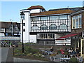
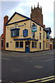
2
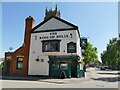
The Ring of Bells, St James's Street, Taunton
A common name for a pub close to a church with bells. It has a new inn sign since 2014, see Image
Image: © Stephen Craven
Taken: 16 Jul 2021
0.01 miles
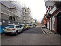
3
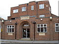
St James Street Pool
Built after the First World War.
Image: © Neil Owen
Taken: 26 May 2014
0.01 miles
4
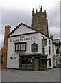
The Ring of Bells
An old street-corner pub with St James looking over its shoulder.
Image: © Neil Owen
Taken: 26 May 2014
0.01 miles
5
St James Street, Taunton
This end of St James Street is pedestrianised up to the Ring of Bells public house, the white building.
Image: © John C
Taken: 26 Jun 2019
0.01 miles
6
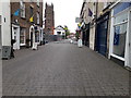
Taunton : St James Street
Looking along the road.
Image: © Lewis Clarke
Taken: 18 Jan 2021
0.01 miles

8
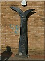
Sustrans sign, Coal Orchard, Taunton
There are hundreds of similar mileposts on the National Cycle Network. This one is the cyclists' equivalent of a motorway sign, being on long distance route 3 and indicating 81.5 miles to Bristol and 183.5 miles to Padstow - at least one day and two days of cycling respectively for even a very fit cyclist.
Image: © Stephen Craven
Taken: 16 Jul 2021
0.02 miles
10
The Ring of Bells Public House
The tower of St James's Church can be seen behind the pub.
Image: © Adrian Boliston
Taken: 11 Feb 2007
0.02 miles