IMAGES TAKEN NEAR TO
Richmond Road, TAUNTON, TA1 1EP
Introduction
This page details the photographs taken nearby to Richmond Road, TA1 1EP by members of the Geograph project.
The Geograph project started in 2005 with the aim of publishing, organising and preserving representative images for every square kilometre of Great Britain, Ireland and the Isle of Man.

There are currently over 7.5m images from over14,400 individuals and you can help contribute to the project by visiting https://www.geograph.org.uk
Image Map (Loading...)


Getting Data...Please wait
Leaflet Map data © OpenStreetMap
Images are licensed for reuse under creativecommons.org/licenses/by-sa/2.0
Notes
- Clicking on the map will re-center to the selected point.
- The higher the marker number, the further away the image location is from the centre of the postcode.
Image Listing (50 Images Found)
Images are licensed for reuse under creativecommons.org/licenses/by-sa/2.0
Image
Details
Distance
1
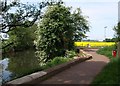
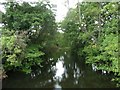
Path by the River Tone
Contrasting colours by the river. The well made-up path may turn away from the riverside at this point, heading into a housing estate at Frieze Hill, but the West Deane Way follows Taunton footpath 3/6 upstream along the edge of the rape field.
Image: © Derek Harper
Taken: 10 May 2008
0.08 miles
2
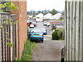
Channel to Channel (352)
Here is looking back through a gate along Roughmoor Crescent.
Image: © Shazz
Taken: 26 Apr 2015
0.08 miles
3
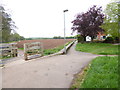
Channel to Channel (350)
The walk departs from the river and turns right along this path between housing and farmland.
Image: © Shazz
Taken: 26 Apr 2015
0.08 miles
4
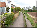
Channel to Channel (351)
Here the camera is looking back towards the River Tone.
Image: © Shazz
Taken: 26 Apr 2015
0.09 miles
5
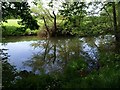
Taunton : The River Tone
The River Tone as seen from a small bridge across it.
Image: © Lewis Clarke
Taken: 5 Aug 2013
0.09 miles
6
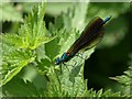
Damselfly by the Tone
This is a male Beautiful Demoiselle (Calopteryx virgo), taken amid nettles by the West Deane Way. (Thanks to Hugh Venables for putting me right on the identification.)
Image: © Derek Harper
Taken: 10 May 2008
0.10 miles
7
Channel to Channel (353)
The route takes this path between allotments and housing. On the right is the wooden gate which gave access to this path.
Image: © Shazz
Taken: 26 Apr 2015
0.10 miles
8
River Tone
From the West Deane Way, which follows Taunton footpath 3/6 along the left bank of the tree-lined river for about 600 metres across this square.
Image: © Derek Harper
Taken: 10 May 2008
0.11 miles
9
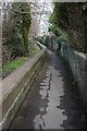
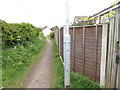
Roughmoor path, Taunton.
Leads to Weirfield Nature Reserve and path along River Tone.
Image: © Nick Chipchase
Taken: 9 Mar 2009
0.13 miles
10
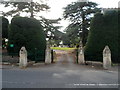
Entrance to St James Cemetery, Taunton
Viewed across Staplegrove Road. The cemetery is maintained by Taunton Deane Borough Council.
Image: © Jaggery
Taken: 11 Sep 2012
0.14 miles