IMAGES TAKEN NEAR TO
Martock Road, LANGPORT, TA10 9LG
Introduction
This page details the photographs taken nearby to Martock Road, TA10 9LG by members of the Geograph project.
The Geograph project started in 2005 with the aim of publishing, organising and preserving representative images for every square kilometre of Great Britain, Ireland and the Isle of Man.

There are currently over 7.5m images from over14,400 individuals and you can help contribute to the project by visiting https://www.geograph.org.uk
Image Map
Images are licensed for reuse under creativecommons.org/licenses/by-sa/2.0
Notes
- Clicking on the map will re-center to the selected point.
- The higher the marker number, the further away the image location is from the centre of the postcode.
Image Listing (10 Images Found)
Images are licensed for reuse under creativecommons.org/licenses/by-sa/2.0
Image
Details
Distance
1
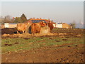
Cattle Feeding near Long Load
Very little grass left in this field due to the cattle churning up the ground so the cattle were feeding on hay. In the background are houses at College Farm.
Image: © Nigel Mykura
Taken: 28 Dec 2016
0.06 miles
2
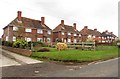
'The Council houses' Long Load
As described by Ordnance Survey. No doubt all in private hands now.
Image: © Roger Cornfoot
Taken: 8 Feb 2017
0.08 miles
5

A dense hedgerow
A big hedge off Long Load Road.
Image: © Richard Webb
Taken: 21 Apr 2011
0.13 miles
6
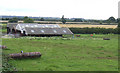
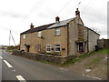
Barns at Orchard Laver Farm
North of Moor Lane near Long Load.
Image: © Jonathan Billinger
Taken: 13 Aug 2007
0.15 miles
7

Cattle by Mare Grove
Mare Grove is the lane between hedges on the far side of the field.
Image: © Richard Webb
Taken: 21 Apr 2011
0.15 miles
8
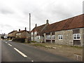
Houses at the southern end of Long Load
Image: © Roger Cornfoot
Taken: 8 Feb 2017
0.16 miles
9
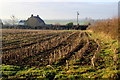
Orchard Laver Farm
The maize stubble is still standing in the field from last year in front of Orchard Laver farmhouse.
Image: © Nigel Mykura
Taken: 28 Dec 2016
0.18 miles
10
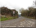
Old Milestone by the B3165, Long Load parish
Stone post (plate lost) by the B3165, in parish of LONG LOAD (SOUTH SOMERSET District), South of village, just South of Mare Drove, buried in hedge beside road, on East side of road. Martock iron plate, erected by the Martock & South Petherton turnpike trust in the 19th century.
Inscription once read:-
(SOMERTON)
(5)
(Martock)
(2)
Somerset HER.
HER number: 14224 https://www.heritagegateway.org.uk/Gateway/Results_Single.aspx?uid=14224&resourceID=100
Milestone Society National ID: SO_SOWL05.
Image: © JR Dowding
Taken: 21 Jan 2006
0.23 miles