IMAGES TAKEN NEAR TO
Hambridge, LANGPORT, TA10 0AU
Introduction
This page details the photographs taken nearby to TA10 0AU by members of the Geograph project.
The Geograph project started in 2005 with the aim of publishing, organising and preserving representative images for every square kilometre of Great Britain, Ireland and the Isle of Man.

There are currently over 7.5m images from over14,400 individuals and you can help contribute to the project by visiting https://www.geograph.org.uk
Image Map
Images are licensed for reuse under creativecommons.org/licenses/by-sa/2.0
Notes
- Clicking on the map will re-center to the selected point.
- The higher the marker number, the further away the image location is from the centre of the postcode.
Image Listing (13 Images Found)
Images are licensed for reuse under creativecommons.org/licenses/by-sa/2.0
Image
Details
Distance
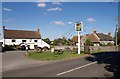
5
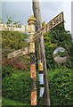
Old Direction Sign - Signpost on the B3168 in Hambridge
Located in Hambridge on the east side of the B3168 opposite Hundry Lane in Hambridge and Westport parish. 3 arms and pyramid finial.
Milestone Society National ID: SO_ST3921
Image: © J Dowding
Taken: Unknown
0.10 miles
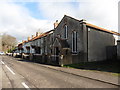
8
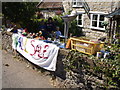
Wall sale, Hambridge
A varied collection of offerings, but alas, I could see nothing I wanted.
Image: © Derek Harper
Taken: 15 Sep 2007
0.14 miles
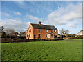
10
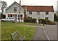
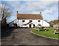
The Lamb and Lion, Hambridge
The C17 and C18 pub (architectural details at http://webapp1.somerset.gov.uk/her/details.asp?prn=22662 ) is set back a long way from the B3168, like the houses to its southwest and northeast. Together they form a broad arc, which must have formerly been the northwest side of the green (behind the camera). The exception is Rose Cottage on the right, which steps out of line and is presumably much newer.
Image: © Derek Harper
Taken: 15 Sep 2007
0.19 miles