IMAGES TAKEN NEAR TO
Mainstone, BISHOPS CASTLE, SY9 5LX
Introduction
This page details the photographs taken nearby to SY9 5LX by members of the Geograph project.
The Geograph project started in 2005 with the aim of publishing, organising and preserving representative images for every square kilometre of Great Britain, Ireland and the Isle of Man.

There are currently over 7.5m images from over14,400 individuals and you can help contribute to the project by visiting https://www.geograph.org.uk
Image Map (4 Images)


Leaflet Map data © OpenStreetMap
Images are licensed for reuse under creativecommons.org/licenses/by-sa/2.0
Notes
- Clicking on the map will re-center to the selected point.
- The higher the marker number, the further away the image location is from the centre of the postcode.
Image Listing (4 Images Found)
Images are licensed for reuse under creativecommons.org/licenses/by-sa/2.0
Image
Details
Distance
2
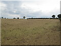
Dry pasture above Hillend
Result of a very dry spell which suspended grass growth for a while.
Image: © Richard Webb
Taken: 3 Sep 2022
0.07 miles
3
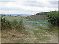
View towards Old Mill Wood
Some steep ground in the Clun Forest.
Image: © Richard Webb
Taken: 3 Sep 2022
0.09 miles
4
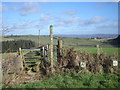
Footpath to Crinkling Wood
The Long Mynd can be seen in the background.
Image: © Row17
Taken: 6 Feb 2008
0.19 miles