IMAGES TAKEN NEAR TO
Woodbatch, BISHOPS CASTLE, SY9 5JS
Introduction
This page details the photographs taken nearby to SY9 5JS by members of the Geograph project.
The Geograph project started in 2005 with the aim of publishing, organising and preserving representative images for every square kilometre of Great Britain, Ireland and the Isle of Man.

There are currently over 7.5m images from over14,400 individuals and you can help contribute to the project by visiting https://www.geograph.org.uk
Image Map
Images are licensed for reuse under creativecommons.org/licenses/by-sa/2.0
Notes
- Clicking on the map will re-center to the selected point.
- The higher the marker number, the further away the image location is from the centre of the postcode.
Image Listing (5 Images Found)
Images are licensed for reuse under creativecommons.org/licenses/by-sa/2.0
Image
Details
Distance
1
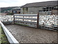
Part of Upper Woodbatch farm
Sheep in a vast flock are penned here awaiting some process. They are almost certainly pregnant ewes.
Image: © Jeremy Bolwell
Taken: 10 Jan 2012
0.06 miles
2
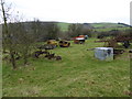
Field at Upper Woodbatch farm
Bric a brac or collectibles? Old mobile generators, agricultural implements and machinery, which is of course to be expected, but even an old safe or strongbox lie in this field. Fascinating.
Image: © Jeremy Bolwell
Taken: 23 Jan 2016
0.07 miles
3
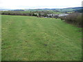
Field above Upper Woodbatch farm near Bishop's Castle
An old field access track remnant remains at the field edge. Sheep winter on pasture near the farm.
Image: © Jeremy Bolwell
Taken: 10 Jan 2012
0.13 miles
4
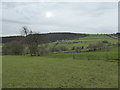
View to Middle Woodbatch farm from Upper Woodbatch farm
Remote farming country.
Image: © Jeremy Bolwell
Taken: 23 Jan 2016
0.13 miles
5
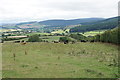
Cattle on Moat Hill
Looking down the hill towards the valley of the River Kemp.
Image: © Bill Boaden
Taken: 20 Aug 2018
0.23 miles