IMAGES TAKEN NEAR TO
Ashford Carbonel, LUDLOW, SY8 4BX
Introduction
This page details the photographs taken nearby to SY8 4BX by members of the Geograph project.
The Geograph project started in 2005 with the aim of publishing, organising and preserving representative images for every square kilometre of Great Britain, Ireland and the Isle of Man.

There are currently over 7.5m images from over14,400 individuals and you can help contribute to the project by visiting https://www.geograph.org.uk
Image Map (Loading...)


Getting Data...Please wait
Leaflet Map data © OpenStreetMap
Images are licensed for reuse under creativecommons.org/licenses/by-sa/2.0
Notes
- Clicking on the map will re-center to the selected point.
- The higher the marker number, the further away the image location is from the centre of the postcode.
Image Listing (216 Images Found)
Images are licensed for reuse under creativecommons.org/licenses/by-sa/2.0
Image
Details
Distance
1
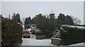
Church Lane, Ashford Carbonell
The postman descends a steep hill towards the main street and site of the old village school. Houses on the right were built on former Home Farm fields in about 1970. Before that we grazed sheep and cattle there.
Image: © Richard Webb
Taken: 24 Dec 2009
0.02 miles
2
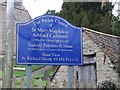
Church notice
The church has been part of a team ministry based on Ludlow since the 1960's. This is right on the gridline.
Image: © Richard Webb
Taken: 24 Dec 2007
0.02 miles
4
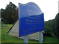
Sign at St. Mary Magdalene Church (Ashford Carbonell)
The entrance sign at St. Mary Magdalene Church in Ashford Carbonell gives you a brief information about the church.
Image: © Fabian Musto
Taken: 26 Dec 2018
0.03 miles
5

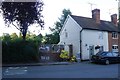
No. 1 and No. 2 Ashford Carbonel
Two small houses. No 1 (painted white) is possibly the smallest house in the village. Very handy for the school.
Image: © Richard Webb
Taken: 24 Dec 2007
0.03 miles
6
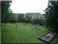
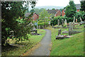
Churchyard at St. Mary Magdalene Church (Ashford Carbonell)
The big churchyard at St. Mary Magdalene Church in Ashford Carbonell stands on a slope, as the church itself is built on a small hill.
Image: © Fabian Musto
Taken: 26 Dec 2018
0.04 miles
7

Signs at Church Lane (Ashford Carbonell)
Two notable signs at Church Lane in Ashford Carbonell.
Image: © Fabian Musto
Taken: 26 Dec 2018
0.04 miles
8
Construction at No.1
What is traditionally thought to be the village's smallest house is getting bigger.
Image: © Richard Webb
Taken: 25 Jul 2015
0.04 miles
9
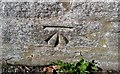
Ordnance Survey Cut Mark
This OS cut mark can be found on the SE face of the old school. It marks a point 77.055m above mean sea level.
Image: © Adrian Dust
Taken: 25 Mar 2017
0.04 miles
10
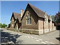
The Old School, Ashford Carbonell
Back in 2007 when photographed by Richard Webb Image] this school was under threat of closure, since then it has closed and been replaced by a modern school on an adjacent greenfield site just to the north. It would have been fitting to have photographed the new school but as the children were out in the play area, I thought better of it. A sad reflection of today's society when taking photographs with children in the frame.
Image: © Philip Halling
Taken: 10 May 2017
0.04 miles