IMAGES TAKEN NEAR TO
Ashford Bowdler, LUDLOW, SY8 4AQ
Introduction
This page details the photographs taken nearby to SY8 4AQ by members of the Geograph project.
The Geograph project started in 2005 with the aim of publishing, organising and preserving representative images for every square kilometre of Great Britain, Ireland and the Isle of Man.

There are currently over 7.5m images from over14,400 individuals and you can help contribute to the project by visiting https://www.geograph.org.uk
Image Map
Images are licensed for reuse under creativecommons.org/licenses/by-sa/2.0
Notes
- Clicking on the map will re-center to the selected point.
- The higher the marker number, the further away the image location is from the centre of the postcode.
Image Listing (4 Images Found)
Images are licensed for reuse under creativecommons.org/licenses/by-sa/2.0
Image
Details
Distance
1
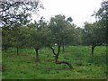
Damson orchard, Ashford Bowdler.
Beside the busy A49, a damson orchard beside a farm shop at Meadowside, near the Skew Bridge.
Image: © Richard Webb
Taken: 11 Sep 2005
0.02 miles
2
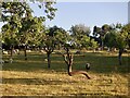
Damson orchard, Meadowside
Beside the A49. Taken 16 years after the first image for this square: Image
The farm shop is still here.
Image: © Richard Webb
Taken: 12 Jun 2021
0.03 miles
3
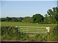
Gate, Ashford Bowdler
Initials may be of the farmer whose surname begins with a B. The field runs down to the River Teme and I passed the other end of the field earlier in the day Image
Image: © Richard Webb
Taken: 12 Jun 2021
0.05 miles
4
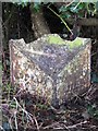
Old Milepost by the A49, north of Woofferton, Ashford Bowdler Parish
Cast iron post by the A49, in parish of ASHFORD BOWDLER (SOUTH SHROPSHIRE District), North of Woofferton, South of driveway to Featherknowl, on West side of road. Ludlow post, erected by the Ludlow (second district) turnpike trust in the 19th century. Damaged
Inscription reads:- : TO / LUDLOW / 3 / MILES : : (ASH)FO(RD) / PARISH : : TO / TENBURY / 6 MILES / LEMSTER / 8 :
Milestone Society National ID: SA_TBLD06.
Image: © A Reade/J Higgins
Taken: 1 Feb 2008
0.25 miles