IMAGES TAKEN NEAR TO
Wheat Common Lane, LUDLOW, SY8 4AF
Introduction
This page details the photographs taken nearby to Wheat Common Lane, SY8 4AF by members of the Geograph project.
The Geograph project started in 2005 with the aim of publishing, organising and preserving representative images for every square kilometre of Great Britain, Ireland and the Isle of Man.

There are currently over 7.5m images from over14,400 individuals and you can help contribute to the project by visiting https://www.geograph.org.uk
Image Map
Images are licensed for reuse under creativecommons.org/licenses/by-sa/2.0
Notes
- Clicking on the map will re-center to the selected point.
- The higher the marker number, the further away the image location is from the centre of the postcode.
Image Listing (13 Images Found)
Images are licensed for reuse under creativecommons.org/licenses/by-sa/2.0
Image
Details
Distance
2
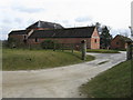
Jonathan Green's Barn
Large 18th Century brick barn at the Rhyse Farm, on the other side of Wheat Common Lane from Ashford Hall, the Lord of the Manor of which at the time it is named after. Grade II listed - see www.historicengland.org.uk/listing/the-list/list-entry/1383617.
Image: © Ian Capper
Taken: 16 Feb 2018
0.05 miles
3
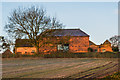
Jonathan Green's Barn
Large 18th Century brick barn at the Rhyse Farm, on the other side of Wheat Common Lane from Ashford Hall, the Lord of the Manor of which at the time it is named after. Grade II listed - see www.historicengland.org.uk/listing/the-list/list-entry/1383617.
Image: © Ian Capper
Taken: 16 Feb 2018
0.05 miles
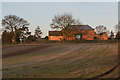
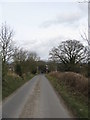
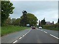
4
Wheatcommon Lane
Pictured from the A49.
Image: © Jonathan Billinger
Taken: 9 Sep 2015
0.17 miles
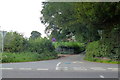
7
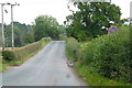
Ashford Bridge
Road to Ashford Carbonell where it crosses the Leominster to Ludlow railway.
Image: © Jonathan Billinger
Taken: 9 Sep 2015
0.22 miles
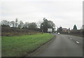
10
Lay-by by A49 north of Ashford Bowdler
Image: © David Smith
Taken: 20 May 2013
0.22 miles