IMAGES TAKEN NEAR TO
Catherton Close, LUDLOW, SY8 3RD
Introduction
This page details the photographs taken nearby to Catherton Close, SY8 3RD by members of the Geograph project.
The Geograph project started in 2005 with the aim of publishing, organising and preserving representative images for every square kilometre of Great Britain, Ireland and the Isle of Man.

There are currently over 7.5m images from over14,400 individuals and you can help contribute to the project by visiting https://www.geograph.org.uk
Image Map
Images are licensed for reuse under creativecommons.org/licenses/by-sa/2.0
Notes
- Clicking on the map will re-center to the selected point.
- The higher the marker number, the further away the image location is from the centre of the postcode.
Image Listing (92 Images Found)
Images are licensed for reuse under creativecommons.org/licenses/by-sa/2.0
Image
Details
Distance
1
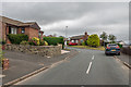
Springfield Park
Estate of mainly bungalows built in the c1980s on land previously belonging to Spring Farm.
Image: © Ian Capper
Taken: 6 Aug 2020
0.02 miles
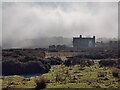
3
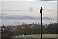
View From Clee Hill
Looking west at the hills rising above the fog
Image: © Mr M Evison
Taken: 23 Dec 2007
0.09 miles
5
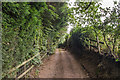
Knapp Lane
Track off Tenbury Road, this section leading to a couple of houses.
Image: © Ian Capper
Taken: 6 Aug 2020
0.14 miles
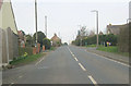
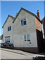
6
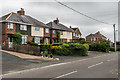
Glenside, Westerley, Bank Crest and Holme Lea
Two pairs of semi-detached houses on Tenbury Road.
Image: © Ian Capper
Taken: 6 Aug 2020
0.14 miles
7
View south from Cleehill
Looking across Shropshire, Worcestershire, and Herefordshire countryside.
Image: © Mat Fascione
Taken: 22 Apr 2011
0.14 miles
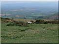
9
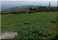
Common land south of Cleehill
Viewed from about 380 metres above sea level.
Image: © Mat Fascione
Taken: 22 Apr 2011
0.14 miles
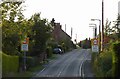
10
Old Toll House, Cleehill
Toll House in Tenbury Road (B4214), in the parish of Coreley.
Surveyed
Milestone Society National ID: SA.NAS03
Image: © Milestone Society
Taken: Unknown
0.14 miles