IMAGES TAKEN NEAR TO
Cornbrook, LUDLOW, SY8 3QG
Introduction
This page details the photographs taken nearby to Cornbrook, SY8 3QG by members of the Geograph project.
The Geograph project started in 2005 with the aim of publishing, organising and preserving representative images for every square kilometre of Great Britain, Ireland and the Isle of Man.

There are currently over 7.5m images from over14,400 individuals and you can help contribute to the project by visiting https://www.geograph.org.uk
Image Map (Loading...)


Getting Data...Please wait
Leaflet Map data © OpenStreetMap
Images are licensed for reuse under creativecommons.org/licenses/by-sa/2.0
Notes
- Clicking on the map will re-center to the selected point.
- The higher the marker number, the further away the image location is from the centre of the postcode.
Image Listing (28 Images Found)
Images are licensed for reuse under creativecommons.org/licenses/by-sa/2.0
Image
Details
Distance
1
View from Clee Hill on a foggy morning
The two hill summits of Abberley Hill and Woodbury Hill just make an appearance out above the temperature inversion below mighty Clee Hill. They look like a smudge of cloud or fog but they are solid terra firma (seen on the 'skyline' of the fog near the top of this shot).
Image: © Jeremy Bolwell
Taken: 12 Dec 2012
0.09 miles
3
View from Clee Hill towards Abberley Hill and Woodbury Hill
On a frosty morning and with a temperature inversion below Clee Hills steep slopes just the tip of these hills make an appearance in the right of shot.
It's minus 3 degrees Celsius on the mountain road and only one degree warmer down in the fog.
Image: © Jeremy Bolwell
Taken: 12 Dec 2012
0.12 miles
5
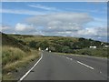
Cornbrook
The Cornbrook reentrant on Clee Hill Common. A nasty bend in the A4117 is well signed. Beyond are the dhustone quarries, now well hidden from ground based eyes.
Image: © Richard Webb
Taken: 21 Jun 2006
0.14 miles
6
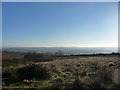
View south-eastwards from Clee Hill Common in December
A bright, sunny and clear day on Clee Hill Common in winter - a rare-ish event.
An ideal opportunity to enjoy the expansive views, here featuring Abberley Hill, Abberley Bell Tower and Woodbury Hill down in Worcestershire. A fascinating spot and a significant landmark.
History could have been very significantly changed by events down their way back in the summer of 1405 when two large, mighty and portentous medieval armies faced each other down for eight days. The force occupying Abberley Hill was the glittering army of the usurping King Henry IV bedecked with his loyal nobles and their fearsome retinues. Opposite, on the old Iron Age hillfort of Woodbury Hill, was a smaller force comprising French nobles and their battle-hardened troops, led by the Welsh wizard Owain Glyndwr and surrounded by fervent Welsh rebels, guerillas and deadly archers. Battle was not joined as the stalemate was not broken. But if they had fought I believe that Henry IV may well have lost and so much would have changed since that even our world today would be very different. It was the battle that never was. Now these hills are little thought of and by-passed by many, unaware of their note.
Image: © Jeremy Bolwell
Taken: 5 Dec 2012
0.14 miles

9
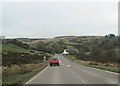
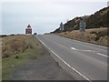
A4117 east beginning the descent of Clee Hill
Just below the disused quarry
Image: © John Firth
Taken: 16 Mar 2012
0.15 miles
10
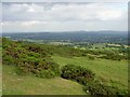
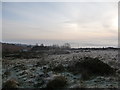
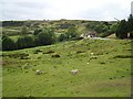
Clee Hill Common
Famed roadside viewpoint high on Clee Hill. View beyond the gorse covered upland heath to Abberley and Woodbury Hill and most of Worcestershire.
Image: © Richard Webb
Taken: 21 Jun 2006
0.16 miles