IMAGES TAKEN NEAR TO
Clee Hill, LUDLOW, SY8 3PN
Introduction
This page details the photographs taken nearby to SY8 3PN by members of the Geograph project.
The Geograph project started in 2005 with the aim of publishing, organising and preserving representative images for every square kilometre of Great Britain, Ireland and the Isle of Man.

There are currently over 7.5m images from over14,400 individuals and you can help contribute to the project by visiting https://www.geograph.org.uk
Image Map
Images are licensed for reuse under creativecommons.org/licenses/by-sa/2.0
Notes
- Clicking on the map will re-center to the selected point.
- The higher the marker number, the further away the image location is from the centre of the postcode.
Image Listing (65 Images Found)
Images are licensed for reuse under creativecommons.org/licenses/by-sa/2.0
Image
Details
Distance
1
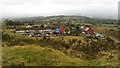
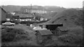
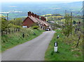
Dhustone Hamlet on the summit road to Titterstone Clee Hill
Rouse Boughton Terrace to the right and New Buildings to the left. Both were built as cottages for the quarrymen who worked at the nearby Dhustone and Titterstone Clee quarries. Railway Terrace just visible behind New Buildings. Home to the workers on the Dhustone incline railway. View taken from the track to one of the current day quarry viewing areas.The road to the side of Rouse Boughton terrace is the road to the summit of Titterstone Clee Hill. Many of the original early concrete structures remain and are part of the living heritage of the hill which is in the Shropshire Area of Outstanding Natural Beauty.
Image: © Ian Loman-Brown
Taken: 2 Mar 2014
0.01 miles
2
Rear of New Buildings, Dhustone
Old quarrymen's houses.
Image: © N Chadwick
Taken: 29 Dec 2010
0.01 miles
3
New Buildings
Late 19th Century terraced housing in Dhustone, originally built for quarryworkers, marked on the 1884 1:2,500 map.
Image: © Ian Capper
Taken: 6 Aug 2020
0.01 miles
4
New Buildings
Late 19th Century terraced housing in Dhustone, originally built for quarryworkers, marked on the 1884 1:2,500 map.
Image: © Ian Capper
Taken: 6 Aug 2020
0.02 miles
5
Cottages at Dhustone Quarry, Clee Hill in 1969
Taken from the trackbed of the railway incline.
Image: © Martin Wynne
Taken: Unknown
0.03 miles
6
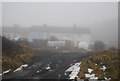
The top end of Rouse-Boughton Terrace, Clee Hill
It may look like this shot was taken in mid-Winter, but it is in fact late May.
Clee Hill seems to be located just above the cloud line - descend a few contour lines and you're back into clear air, wondering why the village was never located a little below its present height.
Not that the locals care - they like it best just as it is.
Image: © Jeremy Bolwell
Taken: 29 May 2013
0.03 miles
7
Dhustone quarry
Quarry now being filled in. Stone is still quarried here, but the dhustone dolerite polishes to easily to be any good as modern roadstone. It is (after 300 odd million years) remelted and spun into rockwool. (According to someone met at an orienteering event up there)
Clee Hill is scarred by many quarries, but has yet to host Dr Who - an ideal location.
Image: © Richard Webb
Taken: 21 Jun 2006
0.04 miles
8
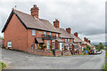
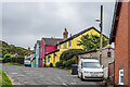
Rouse-Boughton Terrace
Late 19th Century terraced housing in Dhustone, originally built for quarryworkers. The Rouse-Boughtons lived at Downton Hall in Stanton Lacy and owned land here.
Image: © Ian Capper
Taken: 6 Aug 2020
0.04 miles
9
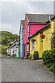
Dhustone: Rouse-Boughton Terrace
A row of former quarrymans cottages along Dhustone Lane.
Image: © Mat Fascione
Taken: 16 May 2012
0.04 miles
10
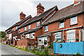
Rouse-Boughton Terrace
Late 19th Century terraced housing in Dhustone, originally built for quarryworkers. The Rouse-Boughtons lived at Downton Hall in Stanton Lacy and owned land here.
Image: © Ian Capper
Taken: 6 Aug 2020
0.04 miles