IMAGES TAKEN NEAR TO
Little Isle, Clee Hill, LUDLOW, SY8 3NW
Introduction
This page details the photographs taken nearby to SY8 3NW by members of the Geograph project.
The Geograph project started in 2005 with the aim of publishing, organising and preserving representative images for every square kilometre of Great Britain, Ireland and the Isle of Man.

There are currently over 7.5m images from over14,400 individuals and you can help contribute to the project by visiting https://www.geograph.org.uk
Image Map (Loading...)


Getting Data...Please wait
Leaflet Map data © OpenStreetMap
Images are licensed for reuse under creativecommons.org/licenses/by-sa/2.0
Notes
- Clicking on the map will re-center to the selected point.
- The higher the marker number, the further away the image location is from the centre of the postcode.
Image Listing (25 Images Found)
Images are licensed for reuse under creativecommons.org/licenses/by-sa/2.0
Image
Details
Distance
1
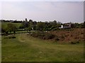
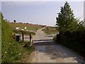
Parkend and Little Isle
Parkend is the house in the foreground, and Little Isle is the group of houses in the left background.
Image: © Ian Capper
Taken: 6 Aug 2020
0.10 miles
2
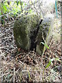
Old Boundary Marker near Park End Cottage, Clee Hill
Two Parish Boundary Markers against a wire fence in a field off a dead-end track adjacent to Park End Cottage, Clee Hill. These are on private land and not in public view.
On the left is SA_COREL01pb, marking Coreley parish, and on the right is SA_NASH01pb, marking Nash parish, both in Shropshire. SA_NASH01pb is inscribed T H, which could refer to Tenbury. Nash parish was part of Tenbury Poor Law Union until 1929 and Tenbury Rural Sanitary District until 1894, both of which comprised parishes in Worcestershire, Shropshire and Herefordshire, but there was never a Tenbury Hundred. Alternatively, Tenbury Rural District built a reservoir 270 metres west of this point by 1902.
Milestone Society National ID: SA_COREL01pb (left) and SA_NASH01pb (right)
Image: © Roadside Relics
Taken: 1 Sep 2022
0.12 miles
3
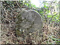
Old Boundary Marker near Park End Cottage, Clee Hill
Parish Boundary Marker against a wire fence in a field off a dead-end track adjacent to Park End Cottage, Clee Hill. This is on private land and not in public view. Inscribed T H, which could refer to Tenbury. Nash parish was part of Tenbury Poor Law Union until 1929 and Tenbury Rural Sanitary District until 1894, both of which comprised parishes in Worcestershire, Shropshire and Herefordshire, but there was never a Tenbury Hundred. Alternatively, Tenbury Rural District built a reservoir 270 metres west of this point by 1902. See https://www.geograph.org.uk/photo/7288066 for a view showing SA_COREL01pb which is immediately behind.
Milestone Society National ID: SA_NASH01pb
Image: © Roadside Relics
Taken: 1 Sep 2022
0.12 miles

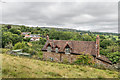
6
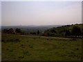
Looking to Worsestershire
From Clee Hill Common
Image: © Mr M Evison
Taken: 1 May 2011
0.17 miles