IMAGES TAKEN NEAR TO
Tenbury Road, LUDLOW, SY8 3NQ
Introduction
This page details the photographs taken nearby to Tenbury Road, SY8 3NQ by members of the Geograph project.
The Geograph project started in 2005 with the aim of publishing, organising and preserving representative images for every square kilometre of Great Britain, Ireland and the Isle of Man.

There are currently over 7.5m images from over14,400 individuals and you can help contribute to the project by visiting https://www.geograph.org.uk
Image Map
Images are licensed for reuse under creativecommons.org/licenses/by-sa/2.0
Notes
- Clicking on the map will re-center to the selected point.
- The higher the marker number, the further away the image location is from the centre of the postcode.
Image Listing (26 Images Found)
Images are licensed for reuse under creativecommons.org/licenses/by-sa/2.0
Image
Details
Distance
4
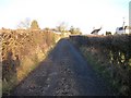
Titrail Lane
Titrail Lane is a track leading off the common and on to Tenbury Road. It is a public bridleway 0514/UN11/1. Just to the right of the gate is the Image
Image: © Hugh Craddock
Taken: 11 Mar 2015
0.06 miles
5
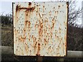
Clee Hill Commons Association notice
Notice erected at an entrance onto the common off Titrail Lane (public bridleway 0523/UN12/1), of some considerable vintage, erected by Clee Hill Commons Association, which advises that it is an offence to drive anywhere on the common under the (now repealed) Road Traffic Act 1960. Also: 'no dumping of rubbish, no dogs allowed off leash, must be exercised on footpath only, not to disturb stock on any part of common. No exercising or schooling of horses on common. All riding must be on bridleways. Offenders will be prosecuted for infringement of registered rights. This is by the order of Clee Hill Commons Association.'
It's perhaps ironic that the notice purports to restrict riding to 'bridleways', since Titrail Lane, a public bridleway, stops at the edge of the common.
Image: © Hugh Craddock
Taken: 11 Mar 2015
0.06 miles
6
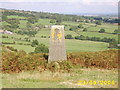
Concrete Pillar
Stands on the Elan Valley Aqueduct. Not sure its purpose though http://www.geograph.org.uk/photo/524695
Image: © Mr M Evison
Taken: 23 Sep 2006
0.07 miles
7
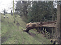
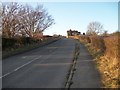
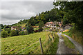
Footpath to Heath Farm
Public footpath 0514/36/6 from Tenbury Road to Heath Farm and Hope Bagot descends steeply down through woodland to join bridleway 0514/42/1 at the bottom of the valley. Straight ahead, a little to the left of the telegraph pole, can be seen one of the Studley Tunnel monuments.
Image: © Hugh Craddock
Taken: 11 Mar 2015
0.08 miles
8
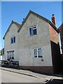
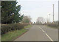
Old Toll House, Cleehill
Toll House in Tenbury Road (B4214), in the parish of Coreley.
Surveyed
Milestone Society National ID: SA.NAS03
Image: © Milestone Society
Taken: Unknown
0.09 miles
10
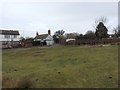
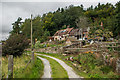
Heathwood House and Heath Farm
Houses below Knowle.
Image: © Ian Capper
Taken: 6 Aug 2020
0.09 miles