IMAGES TAKEN NEAR TO
Clee Hill, LUDLOW, SY8 3ND
Introduction
This page details the photographs taken nearby to SY8 3ND by members of the Geograph project.
The Geograph project started in 2005 with the aim of publishing, organising and preserving representative images for every square kilometre of Great Britain, Ireland and the Isle of Man.

There are currently over 7.5m images from over14,400 individuals and you can help contribute to the project by visiting https://www.geograph.org.uk
Image Map (Loading...)


Getting Data...Please wait
Leaflet Map data © OpenStreetMap
Images are licensed for reuse under creativecommons.org/licenses/by-sa/2.0
Notes
- Clicking on the map will re-center to the selected point.
- The higher the marker number, the further away the image location is from the centre of the postcode.
Image Listing (127 Images Found)
Images are licensed for reuse under creativecommons.org/licenses/by-sa/2.0
Image
Details
Distance
1
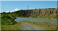
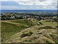
Flooded quarry pit on Titterstone Clee Hill
The long-disused and flooded quarry workings on the Titterstone Clee Hill alongside the road that runs up to the current worked site.
Image: © Peter Evans
Taken: 14 Jun 2014
0.00 miles

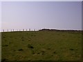
7
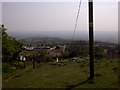
Overlooking the village of Cleehill
Titterstone Clee Hill is the third-highest hill in Shropshire at 533m (1,749 ft). Many derelict quarry buildings are scattered over the slopes of the hill, they were used for the mining of coal, and the quarrying of dhustone (dolerite), used in road-building.
Image: © Mat Fascione
Taken: 19 Sep 2022
0.05 miles
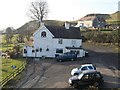
8
Pool House at Clee Hill
Titterstone Clee Hill is the third-highest hill in Shropshire at 533m (1,749 ft). Many derelict quarry buildings are scattered over the slopes of the hill, they were used for the mining of coal, and the quarrying of dhustone (dolerite), used in road-building.
Image: © Mat Fascione
Taken: 19 Sep 2022
0.06 miles
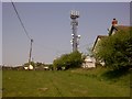
9
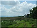
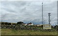
Titterstone Clee house and communications mast
Titterstone Clee house and communications mast, accessible by the road that passes through the quarry processing plant
Image: © Peter Evans
Taken: 14 Jun 2014
0.07 miles