IMAGES TAKEN NEAR TO
Angel Lane, LUDLOW, SY8 3HZ
Introduction
This page details the photographs taken nearby to Angel Lane, SY8 3HZ by members of the Geograph project.
The Geograph project started in 2005 with the aim of publishing, organising and preserving representative images for every square kilometre of Great Britain, Ireland and the Isle of Man.

There are currently over 7.5m images from over14,400 individuals and you can help contribute to the project by visiting https://www.geograph.org.uk
Image Map (Loading...)


Getting Data...Please wait
Leaflet Map data © OpenStreetMap
Images are licensed for reuse under creativecommons.org/licenses/by-sa/2.0
Notes
- Clicking on the map will re-center to the selected point.
- The higher the marker number, the further away the image location is from the centre of the postcode.
Image Listing (3 Images Found)
Images are licensed for reuse under creativecommons.org/licenses/by-sa/2.0
Image
Details
Distance
1
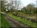
Clee Hill incline at Angel Lane
This was the standard gauge incline up to Dhustone. The embankment of the incline remains clear; it would have crossed the lane on a bridge at this point.
Image: © Alan Murray-Rust
Taken: 27 Apr 2016
0.15 miles
2
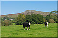
Pastureland
Pastureland on the slopes of Titterstone Clee Hill, whose summit is in the distance. On the left is the row of cottages at Titterstone, marked on older maps as Bedlam.
Image: © Ian Capper
Taken: 19 Sep 2020
0.17 miles
3
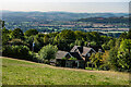
7 Angel Lane
House on the slopes of Titterstone Clee Hill.
Image: © Ian Capper
Taken: 19 Sep 2020
0.23 miles