IMAGES TAKEN NEAR TO
Angel Bank, LUDLOW, SY8 3HT
Introduction
This page details the photographs taken nearby to Angel Bank, SY8 3HT by members of the Geograph project.
The Geograph project started in 2005 with the aim of publishing, organising and preserving representative images for every square kilometre of Great Britain, Ireland and the Isle of Man.

There are currently over 7.5m images from over14,400 individuals and you can help contribute to the project by visiting https://www.geograph.org.uk
Image Map (Loading...)


Getting Data...Please wait
Leaflet Map data © OpenStreetMap
Images are licensed for reuse under creativecommons.org/licenses/by-sa/2.0
Notes
- Clicking on the map will re-center to the selected point.
- The higher the marker number, the further away the image location is from the centre of the postcode.
Image Listing (17 Images Found)
Images are licensed for reuse under creativecommons.org/licenses/by-sa/2.0
Image
Details
Distance
1
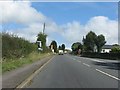
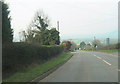
Signs, Angel Bank
On the long drag up Clee Hill.
Image: © Richard Webb
Taken: 29 Jun 2014
0.01 miles
2
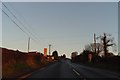
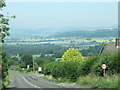
Cloud base along the A4117 near Ludlow
A grainy mobile phone picture of the base of low clouds over the Titterstone Clee looking towards a sunny Ludlow (Ludlow Racecourse in the distance) taken from Angel Bank. This A4117 road drops down from Clee Hill village itself - at the time still engulfed in cloud.
Image: © Peter Evans
Taken: 30 Sep 2020
0.02 miles
4

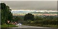
Angel Bank
Named after a now lost pub, Angel Bank has a certain notoriety for steepness and is a rite of passage for local cyclists as well as the source of various playground stories of high speed cycling. It was also the site of motorsport hill climbs.
At this time the road was descending into a thin layer of cloud. The skies were clear again at Ludlow.
Image: © Richard Webb
Taken: 14 Jan 2022
0.11 miles
5
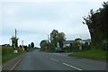
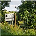
Signs by the A4117 at Angelbank
The motorist driving east is faced with a succession of roadside signs. With the signpost to Knowbury (1 mile) there is a sign to a caravan park and a temporary sign for a fete. These are followed by a "Slow" sign and three warnings, for a slippery road, a junction, and a general warning for emerging vehicles. Finally there is a sign for bed and breakfast
Image: © David Smith
Taken: 20 May 2013
0.11 miles
6
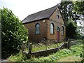
Angel Bank Primitive Methodist Chapel, Bitterley Lane
The foundation stone in the gable is dated 1881. The last service was held here on 17 May 1998.
Image: © Christine Johnstone
Taken: 10 Aug 2011
0.11 miles
7
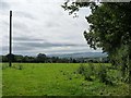
Telegraph pole in grassy field
Alongside the former Angel Bank Primitive Methodist Chapel.
Image: © Christine Johnstone
Taken: 10 Aug 2011
0.12 miles
8
A4117 through Farden
Looking west- phone box can be seen
Image: © John Firth
Taken: 22 Mar 2012
0.12 miles