IMAGES TAKEN NEAR TO
Middleton, LUDLOW, SY8 3DY
Introduction
This page details the photographs taken nearby to SY8 3DY by members of the Geograph project.
The Geograph project started in 2005 with the aim of publishing, organising and preserving representative images for every square kilometre of Great Britain, Ireland and the Isle of Man.

There are currently over 7.5m images from over14,400 individuals and you can help contribute to the project by visiting https://www.geograph.org.uk
Image Map (Loading...)


Getting Data...Please wait
Leaflet Map data © OpenStreetMap
Images are licensed for reuse under creativecommons.org/licenses/by-sa/2.0
Notes
- Clicking on the map will re-center to the selected point.
- The higher the marker number, the further away the image location is from the centre of the postcode.
Image Listing (19 Images Found)
Images are licensed for reuse under creativecommons.org/licenses/by-sa/2.0
Image
Details
Distance
1
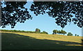
Hillside near The Hills
Looking left from Image] up the valley side from beneath an oak.
Image: © Derek Harper
Taken: 29 Jul 2019
0.09 miles
2
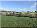
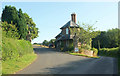
View to Measons farm
A beautifully sited Shropshire farm.
Image: © Jeremy Bolwell
Taken: 13 Feb 2014
0.10 miles
3
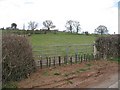
Abandoned gate
Gates cost! This one has just been left for the galvanising to run out and a new hedge planted across it.
Image: © Richard Webb
Taken: 31 Mar 2008
0.10 miles
4
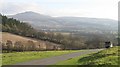
Boxing Day Meet
The South Shropshire Hunt assembling at Downton. Clee Hill in the background.
Image: © Richard Webb
Taken: 26 Dec 2008
0.11 miles
5
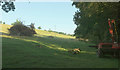
Field near East Lodge
Close to the bridge where Image was taken, with post-driving machinery on the right.
Image: © Derek Harper
Taken: 29 Jul 2019
0.13 miles
7
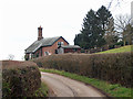
East Lodge
A very interesting and unique lodge on the eastern edge of the Downton Hall estate.
Image: © Jeremy Bolwell
Taken: 13 Feb 2014
0.15 miles
8
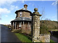
East Lodge
A wider view of Image The lodge, to Downton Hall, dates from 1857 https://historicengland.org.uk/listing/the-list/list-entry/1383655 . The gatepiers are listed separately https://historicengland.org.uk/listing/the-list/list-entry/1383656 and https://historicengland.org.uk/listing/the-list/list-entry/1383657 .
Image: © Derek Harper
Taken: 29 Jul 2019
0.15 miles
9
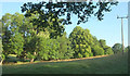
Streamside trees below Measons
From around the bend seen in Image
Image: © Derek Harper
Taken: 29 Jul 2019
0.16 miles
10
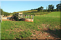
Feeder and pen near The Hills
Looking left from Image The fence meets the hedge at an easting grid line, so only the first 60 metres of this view are in the square.
Image: © Derek Harper
Taken: 29 Jul 2019
0.16 miles