IMAGES TAKEN NEAR TO
Whitbatch, LUDLOW, SY8 3DU
Introduction
This page details the photographs taken nearby to SY8 3DU by members of the Geograph project.
The Geograph project started in 2005 with the aim of publishing, organising and preserving representative images for every square kilometre of Great Britain, Ireland and the Isle of Man.

There are currently over 7.5m images from over14,400 individuals and you can help contribute to the project by visiting https://www.geograph.org.uk
Image Map (Loading...)


Getting Data...Please wait
Leaflet Map data © OpenStreetMap
Images are licensed for reuse under creativecommons.org/licenses/by-sa/2.0
Notes
- Clicking on the map will re-center to the selected point.
- The higher the marker number, the further away the image location is from the centre of the postcode.
Image Listing (14 Images Found)
Images are licensed for reuse under creativecommons.org/licenses/by-sa/2.0
Image
Details
Distance
1
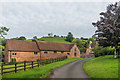
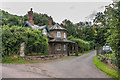
Whitbatch Farm
Farm buildings at Whitbatch Farm. On the right is part of Whitbatch House, dating from the 17th Century with 19th Century additions. Grade II listed - see www.historicengland.org.uk/listing/the-list/list-entry/1218811.
Image: © Ian Capper
Taken: 26 Aug 2017
0.06 miles
2
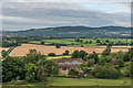
Whitbatch Farm
Looking down on Whitbatch Farm. Nearest is Whitbatch House, dating from the 17th Century with 19th Century additions. Grade II listed - see www.historicengland.org.uk/listing/the-list/list-entry/1218811. Beyond the house are the farm buildings.
In the background is Bringewood, with Ludlow to its left.
Image: © Ian Capper
Taken: 26 Aug 2017
0.06 miles
3
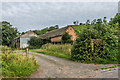
Whitbatch Farm
Farm buildings at Whitbatch Farm.
Image: © Ian Capper
Taken: 26 Aug 2017
0.06 miles
4
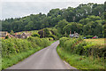
Whitbatch
Looking towards Whitbatch, with Whitbatch Farm on the left and South Lodge to Downton Hall on the right.
Image: © Ian Capper
Taken: 26 Aug 2017
0.08 miles
5
South Lodge
Early 19th Century Lodge to Downton Hall at Whitbatch. The building itself and the railings and gate piers are separately grade II listed - see www.historicengland.org.uk/listing/the-list/list-entry/1291808 and www.historicengland.org.uk/listing/the-list/list-entry/1202852 respectively.
Image: © Ian Capper
Taken: 26 Aug 2017
0.09 miles
6
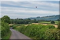
South from Whitbatch
Looking south along the lane that leads from Whitbatch towards Ludlow. In the background a hot air balloon is rising above Ludlow Castle, with the tower of St Laurence's Church also visible towards the left of the photo.
Image: © Ian Capper
Taken: 26 Aug 2017
0.09 miles
7
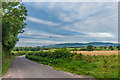
South from Whitbatch
Looking south along the lane that leads from Whitbatch towards Ludlow. In the background a hot air balloon is rising above Ludlow Castle, with Bringewood along the right of the photo.
Image: © Ian Capper
Taken: 26 Aug 2017
0.14 miles
8
Whitbatch
Viciously steep climb from Ludlow on to a sandstone plateau.
Image: © Richard Webb
Taken: 2 Apr 2007
0.15 miles
9
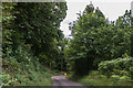
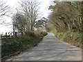
Above Whitbatch
Looking towards the bend on the lane on the steep descent down Whitbatch.
Image: © Ian Capper
Taken: 26 Aug 2017
0.15 miles
10
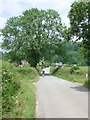
The lane towards Hayton's Bent
approaching Whitbatch Farm
Image: © Andrew Longton
Taken: 25 Jun 2006
0.16 miles