IMAGES TAKEN NEAR TO
Nash, LUDLOW, SY8 3DE
Introduction
This page details the photographs taken nearby to SY8 3DE by members of the Geograph project.
The Geograph project started in 2005 with the aim of publishing, organising and preserving representative images for every square kilometre of Great Britain, Ireland and the Isle of Man.

There are currently over 7.5m images from over14,400 individuals and you can help contribute to the project by visiting https://www.geograph.org.uk
Image Map
Images are licensed for reuse under creativecommons.org/licenses/by-sa/2.0
Notes
- Clicking on the map will re-center to the selected point.
- The higher the marker number, the further away the image location is from the centre of the postcode.
Image Listing (7 Images Found)
Images are licensed for reuse under creativecommons.org/licenses/by-sa/2.0
Image
Details
Distance
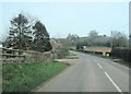
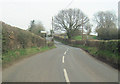
3
View across the south Shropshire countryside
Looking west from the B4214 Clee Hill Road at the Cliffords.
Image: © Mat Fascione
Taken: 29 Dec 2020
0.02 miles
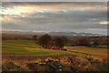
6
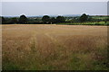
Wheatfield, Lower Nash
Field of wheat near Lower Nash.
Image: © Philip Halling
Taken: 30 Jul 2011
0.18 miles
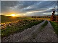
7
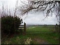
Gate, Lower Nash
Gate with a view west towards the High Vinnalls.
Image: © Richard Webb
Taken: 2 Apr 2006
0.21 miles