IMAGES TAKEN NEAR TO
Belle Vue Terrace, LUDLOW, SY8 2NZ
Introduction
This page details the photographs taken nearby to Belle Vue Terrace, SY8 2NZ by members of the Geograph project.
The Geograph project started in 2005 with the aim of publishing, organising and preserving representative images for every square kilometre of Great Britain, Ireland and the Isle of Man.

There are currently over 7.5m images from over14,400 individuals and you can help contribute to the project by visiting https://www.geograph.org.uk
Image Map (Loading...)


Getting Data...Please wait
Leaflet Map data © OpenStreetMap
Images are licensed for reuse under creativecommons.org/licenses/by-sa/2.0
Notes
- Clicking on the map will re-center to the selected point.
- The higher the marker number, the further away the image location is from the centre of the postcode.
Image Listing (602 Images Found)
Images are licensed for reuse under creativecommons.org/licenses/by-sa/2.0
Image
Details
Distance
2
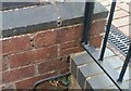
Ordnance Survey Cut Mark
This OS cut mark can be found on the Zion Methodist Chapel. It marks a point 109.320m above mean sea level.
Image: © Adrian Dust
Taken: 25 Nov 2021
0.05 miles
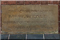
3
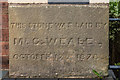
Foundation stone, former Zion Methodist Chapel, New Road
One of six foundation stones dated 17 October 1878 on the former Zion Methodist Chapel in New Road, now converted to housing - see Image
The name on this one is Mr C Weale.
Image: © Ian Capper
Taken: 26 Aug 2017
0.06 miles
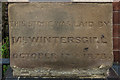
4
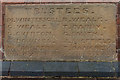
Foundation stone, former Zion Methodist Chapel, New Road
One of six foundation stones dated 17 October 1878 on the former Zion Methodist Chapel in New Road, now converted to housing - see Image
The names on this one are those of the Trustees of the chapel, M Wintersgill, C Weale, G Overton, T Downes, W Saunders, W Cox, B Weale, G Smith, J Sheffields, T Bangrey and C F Williams.
Image: © Ian Capper
Taken: 26 Aug 2017
0.06 miles
5
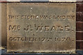
Foundation stone, former Zion Methodist Chapel, New Road
One of six foundation stones dated 17 October 1878 on the former Zion Methodist Chapel in New Road, now converted to housing - see Image
The name on this one is Mr J Weale.
Image: © Ian Capper
Taken: 26 Aug 2017
0.06 miles
6
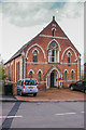
Zion Chapel
Former Methodist chapel in New Road, built in 1878 but now converted to housing. For wider view see Image For photos of the foundation stones see across the base of the façade see http://www.geograph.org.uk/snippet/17037.
Image: © Ian Capper
Taken: 10 Apr 2009
0.06 miles
7
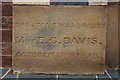
Foundation stone, former Zion Methodist Chapel, New Road
One of six foundation stones dated 17 October 1878 on the former Zion Methodist Chapel in New Road, now converted to housing - see Image
The name on this one is Miss E G Davis.
Image: © Ian Capper
Taken: 26 Aug 2017
0.06 miles
8
Foundation stone, former Zion Methodist Chapel, New Road
One of six foundation stones dated 17 October 1878 on the former Zion Methodist Chapel in New Road, now converted to housing - see Image
The name on this one is Mr W Weale, "on behalf of the Sunday School".
Image: © Ian Capper
Taken: 26 Aug 2017
0.06 miles
9
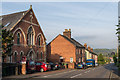
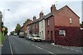
New Road
On the left is the former Zion Methodist Chapel, built in 1878 but now converted to housing.
Image: © Ian Capper
Taken: 5 May 2014
0.06 miles
10
Foundation stone, former Zion Methodist Chapel, New Road
One of six foundation stones dated 17 October 1878 on the former Zion Methodist Chapel in New Road, now converted to housing - see Image
The name on this one is Mr Wintersgill.
Image: © Ian Capper
Taken: 26 Aug 2017
0.06 miles