IMAGES TAKEN NEAR TO
Fishmore Road, LUDLOW, SY8 2LU
Introduction
This page details the photographs taken nearby to Fishmore Road, SY8 2LU by members of the Geograph project.
The Geograph project started in 2005 with the aim of publishing, organising and preserving representative images for every square kilometre of Great Britain, Ireland and the Isle of Man.

There are currently over 7.5m images from over14,400 individuals and you can help contribute to the project by visiting https://www.geograph.org.uk
Image Map (Loading...)


Getting Data...Please wait
Leaflet Map data © OpenStreetMap
Images are licensed for reuse under creativecommons.org/licenses/by-sa/2.0
Notes
- Clicking on the map will re-center to the selected point.
- The higher the marker number, the further away the image location is from the centre of the postcode.
Image Listing (222 Images Found)
Images are licensed for reuse under creativecommons.org/licenses/by-sa/2.0
Image
Details
Distance
1
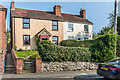
5 and 10 Fishmore Road
Pair of semi-detached cottages on Fishmore Road dating from the 19th Century. The unusual numbering is because nos 6, 7 and 8 - 9 are behind these, accessed by a side track.
Image: © Ian Capper
Taken: 20 Sep 2020
0.00 miles
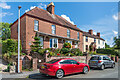
2
13- 14 Fishmore Road
Pair of semi-detached cottages on Fishmore Road dating from the late 19th/early 20th Century.
Image: © Ian Capper
Taken: 20 Sep 2020
0.01 miles
3
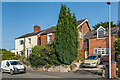
5 and 10 and 13 - 14 Fishmore Road
Two pairs of semi-detached cottages on Fishmore Road. Nos 13 - 14 (the nearer building - see Image for closer view) date from the late 19th/early 20th Century and nos 5 and 10 (beyond - see Image) are 19th Century. The unusual numbering of the latter is because nos 6, 7 and 8 - 9 are behind these, accessed by a side track.
Image: © Ian Capper
Taken: 2 Aug 2020
0.01 miles
4
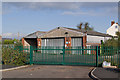
Former bus depot
Former bus depot of the Whittle Bus and Coach Company.
Image: © Ian Capper
Taken: 16 Oct 2011
0.02 miles
5
15 - 18 Fishmore Road
Two pairs of semi-detached cottages on Fishmore Road dating originally the 19th Century, although the extension to no 15, on the right, dates from the c.1980s.
Image: © Ian Capper
Taken: 20 Sep 2020
0.03 miles
6
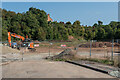
Former Fishmore Brick and Pipe Works site
After having been derelict for decades, operations having ceased in 1948, development of this former brickworks and quarry site is now starting, with 78 residence of various types and sizes due to be built. The initial name for the site is Quarry Place, but this could change.
Image: © Ian Capper
Taken: 20 Sep 2020
0.04 miles
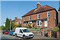
7
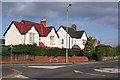
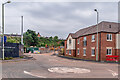
Fishmore Road
Houses on Fishmore Road at its junction with Whitbatch Close.
Image: © Ian Capper
Taken: 16 Oct 2011
0.04 miles
8
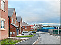
Quarry Place
Part completed development on the site of the former Fishmore Brick and Pipe Works off Fishmore Road. Although the development has gone under the name "Quarry Place", it appears that the official street name will be Raglan Place, commemorating the quarrying of Raglan mudstone on the site for brickmaking.
Image: © Ian Capper
Taken: 28 Dec 2021
0.04 miles
9
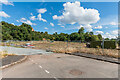
Former Fishmore Brick and Pipe Works site
After having been derelict for decades, operations having ceased in 1948, development of this former brickworks and quarry site is now starting, with 78 residence of various types and sizes due to be built. The initial name for the site is Quarry Place, but this could change.
Image: © Ian Capper
Taken: 2 Aug 2020
0.04 miles
10
Quarry Place
Part completed development on the site of the former Fishmore Brick and Pipe Works off Fishmore Road. The building here, consisting of 6 apartments, is named Kiln Court.
Image: © Ian Capper
Taken: 24 Jul 2021
0.05 miles