IMAGES TAKEN NEAR TO
Stoke St. Milborough, LUDLOW, SY8 2EL
Introduction
This page details the photographs taken nearby to SY8 2EL by members of the Geograph project.
The Geograph project started in 2005 with the aim of publishing, organising and preserving representative images for every square kilometre of Great Britain, Ireland and the Isle of Man.

There are currently over 7.5m images from over14,400 individuals and you can help contribute to the project by visiting https://www.geograph.org.uk
Image Map
Images are licensed for reuse under creativecommons.org/licenses/by-sa/2.0
Notes
- Clicking on the map will re-center to the selected point.
- The higher the marker number, the further away the image location is from the centre of the postcode.
Image Listing (4 Images Found)
Images are licensed for reuse under creativecommons.org/licenses/by-sa/2.0
Image
Details
Distance
2
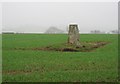
Weston Hill
High level arable land in the Clee Hills. The triangulation pillar is 321m above sea level.
Image: © Richard Webb
Taken: 12 Feb 2004
0.21 miles
3
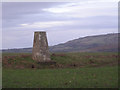
Trig point on Weston Hill
Brown Clee Hill looms in the distance.
Image: © Row17
Taken: 26 Feb 2009
0.21 miles
4
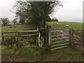
Gates, Scirmidge
High pasture near Cold Weston.
Image: © Richard Webb
Taken: 27 Dec 2018
0.22 miles