IMAGES TAKEN NEAR TO
Sutton, Stanton Lacy, LUDLOW, SY8 2AN
Introduction
This page details the photographs taken nearby to SY8 2AN by members of the Geograph project.
The Geograph project started in 2005 with the aim of publishing, organising and preserving representative images for every square kilometre of Great Britain, Ireland and the Isle of Man.

There are currently over 7.5m images from over14,400 individuals and you can help contribute to the project by visiting https://www.geograph.org.uk
Image Map
Images are licensed for reuse under creativecommons.org/licenses/by-sa/2.0
Notes
- Clicking on the map will re-center to the selected point.
- The higher the marker number, the further away the image location is from the centre of the postcode.
Image Listing (6 Images Found)
Images are licensed for reuse under creativecommons.org/licenses/by-sa/2.0
Image
Details
Distance
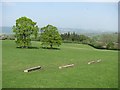
2
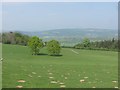
Pasture above Corve Dale
Sloping grassland with one of many small woods.
Image: © Richard Webb
Taken: 22 Apr 2011
0.14 miles
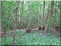
3
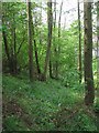
Woodland corner
The steep slopes where a plateau falls to Corvedale.
Image: © Richard Webb
Taken: 22 Apr 2011
0.18 miles
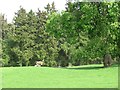
4
Suttonhill Coppice
Brambly woodland on a steep slope falling towards Corvedale.
Image: © Richard Webb
Taken: 22 Apr 2011
0.20 miles
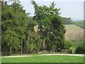
5
Pasture, Sutton Hill
Grassland in a dry spell with a view over Corve Dale.
Image: © Richard Webb
Taken: 22 Apr 2011
0.24 miles