IMAGES TAKEN NEAR TO
Lawton, Stanton Lacy, LUDLOW, SY8 2AL
Introduction
This page details the photographs taken nearby to SY8 2AL by members of the Geograph project.
The Geograph project started in 2005 with the aim of publishing, organising and preserving representative images for every square kilometre of Great Britain, Ireland and the Isle of Man.

There are currently over 7.5m images from over14,400 individuals and you can help contribute to the project by visiting https://www.geograph.org.uk
Image Map (Loading...)


Getting Data...Please wait
Leaflet Map data © OpenStreetMap
Images are licensed for reuse under creativecommons.org/licenses/by-sa/2.0
Notes
- Clicking on the map will re-center to the selected point.
- The higher the marker number, the further away the image location is from the centre of the postcode.
Image Listing (10 Images Found)
Images are licensed for reuse under creativecommons.org/licenses/by-sa/2.0
Image
Details
Distance
2
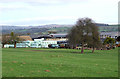
Mediaeval Field Patterns, Lawton, Shropshire
The patterns show well in the low winter sunlight.This is the reverse direction of the image Image] where I had no idea on what I was walking. The public bridleway goes diagonally up the slope to one of the gaps, where there is now a gate.
Image: © Roger D Kidd
Taken: 26 Jan 2008
0.18 miles
3
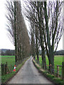
Lane from Lawton Farm, Shropshire
The poplars would have been leaning even more to the left if today's stiff breeze from the west had been blowing onto leaf laden summer trees.
Image: © Roger D Kidd
Taken: 26 Jan 2008
0.21 miles
4
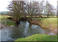
River Corve at Lawton, Shropshire
Looking north-east along the flood plain.
Image: © Roger D Kidd
Taken: 26 Jan 2008
0.22 miles
5
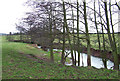
River Corve at Lawton, Shropshire
Looking east to the bridleway bridge.
Image: © Roger D Kidd
Taken: 26 Jan 2008
0.22 miles
6
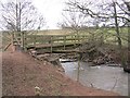
Bridge over the Corve
Note the anti-lamb defences on the gate.
Image: © Richard Webb
Taken: 1 Apr 2013
0.23 miles
7
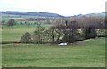
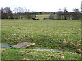
Grazing Land by the River Corve at Lawton, Shropshire
The footpath crosses this field down to a footbridge just visible on the far right of the picture.
Image: © Roger D Kidd
Taken: 26 Jan 2008
0.23 miles
8
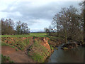
River Corve near Lawton, Shropshire
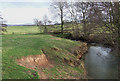
The colour of the soil falling from the eroded bank reveal the predominantly red sandstone strata through which the river flows further upstream. A bridge carrying the bridleway from Lawton towards Diddlebury is just visible in the trees.
Image: © Roger D Kidd
Taken: 26 Jan 2008
0.24 miles
9
River Corve at Lawton, Shropshire
The colour of the soil reflects its red sandstone origins. The footbridge in the trees carries a public bridleway (from the farm at Lawton) to Diddlebury.
Image: © Roger D Kidd
Taken: 26 Jan 2008
0.24 miles
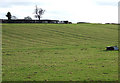
10
Towards Lawton, Shropshire
The public footpath from Corfton crosses the "occasional" watercourse (or drainage channel) by means of a large slab of limestone. The farm buildings of Lawton can be seen on the skyline.
Image: © Roger D Kidd
Taken: 26 Jan 2008
0.25 miles