IMAGES TAKEN NEAR TO
Sutton, Stanton Lacy, LUDLOW, SY8 2AJ
Introduction
This page details the photographs taken nearby to SY8 2AJ by members of the Geograph project.
The Geograph project started in 2005 with the aim of publishing, organising and preserving representative images for every square kilometre of Great Britain, Ireland and the Isle of Man.

There are currently over 7.5m images from over14,400 individuals and you can help contribute to the project by visiting https://www.geograph.org.uk
Image Map
Images are licensed for reuse under creativecommons.org/licenses/by-sa/2.0
Notes
- Clicking on the map will re-center to the selected point.
- The higher the marker number, the further away the image location is from the centre of the postcode.
Image Listing (4 Images Found)
Images are licensed for reuse under creativecommons.org/licenses/by-sa/2.0
Image
Details
Distance
3
Through a hedge, forwards
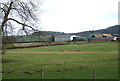
Grass fields and the alder lined Pye Brook in Corvedale. It is pretty hopeless trying to do this square from the road, you need to get into the fields as the hedges are very high.
Image: © Richard Webb
Taken: 5 Apr 2012
0.22 miles
4
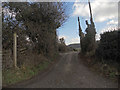
A road in Corvedale
The road which runs up the eastern side of Corvedale from Ludlow and Stanton Lacy.
Image: © Richard Webb
Taken: 5 Apr 2012
0.24 miles