IMAGES TAKEN NEAR TO
Henley Orchards, LUDLOW, SY8 1TW
Introduction
This page details the photographs taken nearby to Henley Orchards, SY8 1TW by members of the Geograph project.
The Geograph project started in 2005 with the aim of publishing, organising and preserving representative images for every square kilometre of Great Britain, Ireland and the Isle of Man.

There are currently over 7.5m images from over14,400 individuals and you can help contribute to the project by visiting https://www.geograph.org.uk
Image Map (Loading...)


Getting Data...Please wait
Leaflet Map data © OpenStreetMap
Images are licensed for reuse under creativecommons.org/licenses/by-sa/2.0
Notes
- Clicking on the map will re-center to the selected point.
- The higher the marker number, the further away the image location is from the centre of the postcode.
Image Listing (118 Images Found)
Images are licensed for reuse under creativecommons.org/licenses/by-sa/2.0
Image
Details
Distance
1
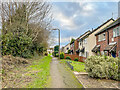
Dodmore Lane
Footpath which clearly pre-exists the 1980s development of this area of Ludlow, something which is confirmed in old maps which show it as a track called Dodmore Lane. The houses on the right, although accessed from this path, have addresses in Lime Close, on their opposite side.
Image: © Ian Capper
Taken: 28 Dec 2021
0.09 miles
2
Dodmore Lane
Footpath which clearly pre-exists the 1980s development of this area of Ludlow, something which is confirmed in old maps which show it as a track called Dodmore Lane. The houses on the left, although accessed from this path, have addresses in Lime Close, on their opposite side.
Image: © Ian Capper
Taken: 28 Dec 2021
0.09 miles
3
Dodmore Lane
Footpath which clearly pre-exists the 1980s development of this area of Ludlow, something which is confirmed in old maps which show it as a track called Dodmore Lane. The houses on the right, although accessed from this path, have addresses in Lime Close, on their opposite side.
Image: © Ian Capper
Taken: 28 Dec 2021
0.10 miles
4
Dodmore Lane
Footpath which clearly pre-exists the 1980s development of this area of Ludlow, something which is confirmed in old maps which show it as a track called Dodmore Lane.
Image: © Ian Capper
Taken: 28 Dec 2021
0.10 miles
5
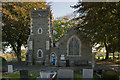
Ludlow Cemetery Chapel
Chapel in Ludlow Cemetery, off Henley Road.
Image: © Ian Capper
Taken: 16 Oct 2011
0.10 miles
6
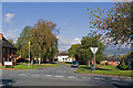
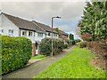
Weyman Road
A road off Henley Road, first developed in the 1980s. The Weyman family were a prominent Ludlow family, including local solicitor Henry and novelist Stanley.
Image: © Ian Capper
Taken: 16 Oct 2011
0.11 miles
7
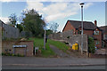
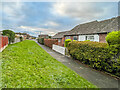
Bridleway off Stanton Road
Clearly pre-existing the 1980s development of this area of Ludlow, this is confirmed in old maps which show it as a track called Dodmore Lane. It survives as this bridleway connecting Stanton Road and Lacy Road.
Image: © Ian Capper
Taken: 16 Oct 2011
0.11 miles
8
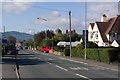
Henley Road
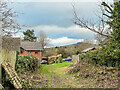
The route eastwards out of Ludlow. In the centre can be seen the dome of St Peter's RC Church. The high ground in the background is Bringewood.
Image: © Ian Capper
Taken: 16 Oct 2011
0.11 miles
9
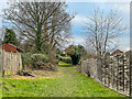
Dodmore Lane
Footpath which clearly pre-exists the 1980s development of this area of Ludlow, something which is confirmed in old maps which show it as a track called Dodmore Lane. In the distance is Titterstone Clee Hill.
Image: © Ian Capper
Taken: 28 Dec 2021
0.11 miles
10

Ludlow Cemetery
Towards the chapel from the Clee View path. There was a room where we could have our flask of tea, it contained a record of all the burials. The effect of the Winter of 1947 was all to clear to see there. I was very busy in 1979 too, a very harsh Winter.
Image: © Richard Webb
Taken: 14 Jan 2022
0.11 miles