IMAGES TAKEN NEAR TO
Jockey Fields, LUDLOW, SY8 1TP
Introduction
This page details the photographs taken nearby to Jockey Fields, SY8 1TP by members of the Geograph project.
The Geograph project started in 2005 with the aim of publishing, organising and preserving representative images for every square kilometre of Great Britain, Ireland and the Isle of Man.

There are currently over 7.5m images from over14,400 individuals and you can help contribute to the project by visiting https://www.geograph.org.uk
Image Map (Loading...)


Getting Data...Please wait
Leaflet Map data © OpenStreetMap
Images are licensed for reuse under creativecommons.org/licenses/by-sa/2.0
Notes
- Clicking on the map will re-center to the selected point.
- The higher the marker number, the further away the image location is from the centre of the postcode.
Image Listing (1623 Images Found)
Images are licensed for reuse under creativecommons.org/licenses/by-sa/2.0
Image
Details
Distance
1
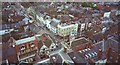
Broad Street from St Laurence's
Looking down from the tower of St Laurence's Church, Ludlow at the grid street patterns of this medieval planned town.
Image: © Richard Webb
Taken: 2 Aug 2002
0.00 miles
4
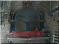
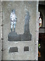
Sir Job Charlton
The effigy of Sir Job Charlton at St Giles, Ludford. Sir Job was a judge, hence the red robes. He was also, for a short time, the Speaker of the House of Commons. He was removed from his post of Chief Justice for Chester to make room for Judge Jeffries.
Image: © Eirian Evans
Taken: 1 Jun 2008
0.00 miles
5
The Foxes of Ludford
A brass rubbing of Edward Foxe and his wife Jane in the church at Ludford. They had 24 children, most of whom survived to adulthood.
Image: © Eirian Evans
Taken: 1 Jun 2008
0.00 miles
6

Ludlow: St. Laurence's Church: Misericord North 4
The Hart at Rest.
The badge of Richard II,deposed by Lancastrian Henry IV; the hounds for the chase are on either side.
Image: © Michael Garlick
Taken: 14 Aug 2015
0.00 miles
7
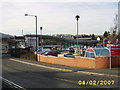
Friar's Gardens
Built on the site of "The Trouser Factory", where a lot of Rohan clothing used to be made by Walters. Like most of Ludlow's industry the factory is long gone. This view from Friar's Walk would have looked up a grassy bank towards the factory canteen.
Image: © Richard Webb
Taken: 14 Feb 2009
0.02 miles
8

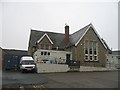
St Laurence's C of E Primary School
In 1972 St Laurence's C of E Primary School closed. It merged with the former British School on Old Street and Ludlow had just one primary school. This is the site of the shared sports field of the two schools. The pitch was not developed for housing and in recent years the Church has reopened its school in Ludlow and after a few lost decades the school is back, about the same size as before the merger and is now situated just down Friar's Walk from its 1959-72 site in Galdeford.
Image: © Richard Webb
Taken: 14 Feb 2009
0.02 miles
9
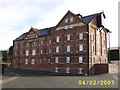
Community Furniture Scheme
South Shropshire Community Furniture Scheme occupies a former infant's school.
Image: © Richard Webb
Taken: 14 Feb 2009
0.03 miles
10

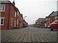
Friar's Walk
A path between Galdeford and Old Street.
Image: © Richard Webb
Taken: 20 Oct 2015
0.03 miles