IMAGES TAKEN NEAR TO
Lower Galdeford, LUDLOW, SY8 1TE
Introduction
This page details the photographs taken nearby to Lower Galdeford, SY8 1TE by members of the Geograph project.
The Geograph project started in 2005 with the aim of publishing, organising and preserving representative images for every square kilometre of Great Britain, Ireland and the Isle of Man.

There are currently over 7.5m images from over14,400 individuals and you can help contribute to the project by visiting https://www.geograph.org.uk
Image Map (Loading...)


Getting Data...Please wait
Leaflet Map data © OpenStreetMap
Images are licensed for reuse under creativecommons.org/licenses/by-sa/2.0
Notes
- Clicking on the map will re-center to the selected point.
- The higher the marker number, the further away the image location is from the centre of the postcode.
Image Listing (1941 Images Found)
Images are licensed for reuse under creativecommons.org/licenses/by-sa/2.0
Image
Details
Distance
1
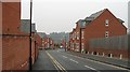
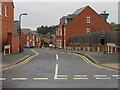
Friar's Gardens
Housing estate on the site of the Trouser Factory (Walter's).
Image: © Richard Webb
Taken: 14 Feb 2009
0.02 miles
2
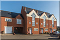
Friars Garden
Development off Lower Galdeford dating from 1990/2000. Old maps mark this area as the "Friars' Garden".
Image: © Ian Capper
Taken: 11 Mar 2016
0.03 miles
3
The Green Green Grass On Location
Filming taking place in Ludlow on location with Boycie,Marleen and Taylor
Image: © Mr M Evison
Taken: 10 Jun 2007
0.03 miles
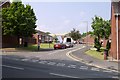
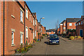
5
Friars Garden, Ludlow
Residential street descending from Lower Galdeford towards Abbotts Row.
Image: © Jaggery
Taken: 9 Nov 2015
0.03 miles
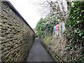
6

Friar's Walk
A path between Galdeford and Old Street.
Image: © Richard Webb
Taken: 20 Oct 2015
0.04 miles
7
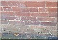
Ordnance Survey Cut Mark
This OS cut mark can be found on No4 Friars Walk. It marks a point 87.225m above mean sea level.
Image: © Adrian Dust
Taken: 25 Nov 2021
0.04 miles
8
Friars Garden
Development off Lower Galdeford dating from 1990/2000. Old maps mark this area as the "Friars' Garden".
Image: © Ian Capper
Taken: 11 Mar 2016
0.04 miles
9
Friar's Walk
Passing between the old St Lawrence School site and where the police station used to be. Friar's Walk links Old Street and Galdeford along the site of the town walls.
Image: © Richard Webb
Taken: 7 Apr 2014
0.04 miles
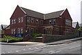
10
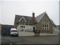
Community Furniture Scheme
South Shropshire Community Furniture Scheme occupies a former infant's school.
Image: © Richard Webb
Taken: 14 Feb 2009
0.04 miles