IMAGES TAKEN NEAR TO
Chandlers Close, LUDLOW, SY8 1SB
Introduction
This page details the photographs taken nearby to Chandlers Close, SY8 1SB by members of the Geograph project.
The Geograph project started in 2005 with the aim of publishing, organising and preserving representative images for every square kilometre of Great Britain, Ireland and the Isle of Man.

There are currently over 7.5m images from over14,400 individuals and you can help contribute to the project by visiting https://www.geograph.org.uk
Image Map
Images are licensed for reuse under creativecommons.org/licenses/by-sa/2.0
Notes
- Clicking on the map will re-center to the selected point.
- The higher the marker number, the further away the image location is from the centre of the postcode.
Image Listing (1783 Images Found)
Images are licensed for reuse under creativecommons.org/licenses/by-sa/2.0
Image
Details
Distance
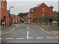
1
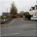
Chandlers Close, Ludlow
Viewed across Lower Galdeford.
Image: © Jaggery
Taken: 9 Nov 2015
0.02 miles
2
The Green Green Grass On Location
Filming taking place in Ludlow on location with Boycie,Marleen and Taylor
Image: © Mr M Evison
Taken: 10 Jun 2007
0.02 miles
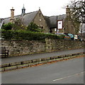
4

Former school
St Lawrence's School occupied the older building between the late 1950s and 1972. The newer building was built later on, on the site of the terrifyingly insanitary toilet block.
Image: © Richard Webb
Taken: 10 Aug 2013
0.02 miles
5
Former school
The Victorian buildings once housed St Lawrence's School between the late 1950s and 1972 and is now used by the diocese as a conference centre. The car park here was the boy's playground (ie break football arena). As you can imagine the conker tree was popular.
Image: © Richard Webb
Taken: 10 Aug 2013
0.03 miles
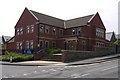
6
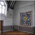
Bishop Mascall Centre
Diocese of Hereford conference centre in the old St Lawrence and Ludlow Secondary Modern building in Galdeford. This was the assembly hall and this would have been a teacher's eye view while we listened to Pete Seeger songs, watched Moon landings and experienced more child centred acts of worship than was the case at Ashford Carbonel school. Coming here as a 7 year old feels now like a 40 year jump in a single Summer holiday.
My first visit to this room since 1972. There is a very good cafe next door.
Image: © Richard Webb
Taken: 21 Oct 2015
0.03 miles
7
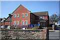
Ludlow Police Station
Modern building in Lower Galdeford.
Image: © Pauline E
Taken: 7 Mar 2010
0.03 miles
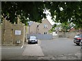
8
LMC (Ludlow Mascall Centre)
Viewed across Lower Galdeford. Ludlow Mascall Centre occupies a former National School built in 1857.
The building later housed a secondary school and then a junior school.
In the 1970s the building was extended and became an educational charity.
Today, Ludlow Mascall Centre offers a range of rooms for hire
as well as residential accommodation and a full catering service.
Image: © Jaggery
Taken: 9 Nov 2015
0.03 miles
9
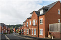
Friars Garden
Development off Lower Galdeford dating from 1990/2000. Old maps mark this area as the "Friars' Garden".
Image: © Ian Capper
Taken: 22 May 2016
0.04 miles
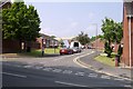
10
Friars Garden, Ludlow
Residential street descending from Lower Galdeford towards Abbotts Row.
Image: © Jaggery
Taken: 9 Nov 2015
0.04 miles