IMAGES TAKEN NEAR TO
Friars Garden, LUDLOW, SY8 1RX
Introduction
This page details the photographs taken nearby to Friars Garden, SY8 1RX by members of the Geograph project.
The Geograph project started in 2005 with the aim of publishing, organising and preserving representative images for every square kilometre of Great Britain, Ireland and the Isle of Man.

There are currently over 7.5m images from over14,400 individuals and you can help contribute to the project by visiting https://www.geograph.org.uk
Image Map
Images are licensed for reuse under creativecommons.org/licenses/by-sa/2.0
Notes
- Clicking on the map will re-center to the selected point.
- The higher the marker number, the further away the image location is from the centre of the postcode.
Image Listing (2214 Images Found)
Images are licensed for reuse under creativecommons.org/licenses/by-sa/2.0
Image
Details
Distance
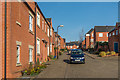
1
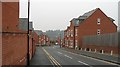
Friar's Gardens
Housing estate on the site of the Trouser Factory (Walter's).
Image: © Richard Webb
Taken: 14 Feb 2009
0.01 miles
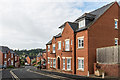
2
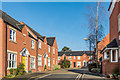
Friars Garden
Development off Lower Galdeford dating from 1990/2000. Old maps mark this area as the "Friars' Garden".
Image: © Ian Capper
Taken: 11 Mar 2016
0.01 miles
3
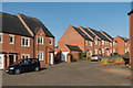
Friars Garden
Development off Lower Galdeford dating from 1990/2000. Old maps mark this area as the "Friars' Garden".
Image: © Ian Capper
Taken: 11 Mar 2016
0.01 miles
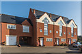
4
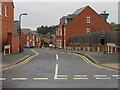
Friars Garden, Ludlow
Residential street descending from Lower Galdeford towards Abbotts Row.
Image: © Jaggery
Taken: 9 Nov 2015
0.02 miles
5
Friars Garden
Development off Lower Galdeford dating from 1990/2000. Old maps mark this area as the "Friars' Garden".
Image: © Ian Capper
Taken: 11 Mar 2016
0.03 miles
6
Friars Garden
Development off Lower Galdeford dating from 1990/2000. Old maps mark this area as the "Friars' Garden".
Image: © Ian Capper
Taken: 22 May 2016
0.03 miles
7
Friars Garden
Development off Lower Galdeford dating from 1990/2000. Old maps mark this area as the "Friars' Garden".
Image: © Ian Capper
Taken: 11 Mar 2016
0.04 miles
8
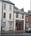
Former fire station
Until the 1960s the tile shop was the fire station, complete with pole. Then it was used by Ludlow Museum as storage.
Image: © Richard Webb
Taken: 14 Feb 2009
0.04 miles
9
Ludlow: St. Laurence's Church: East wall mounted sculpture in the Lady Chapel
Image: © Michael Garlick
Taken: 14 Aug 2015
0.04 miles
10
Ludlow: St. Laurence's Church: East wall mounted sculpture in the Lady Chapel
Image: © Michael Garlick
Taken: 14 Aug 2015
0.04 miles