IMAGES TAKEN NEAR TO
Ludford, LUDLOW, SY8 1PJ
Introduction
This page details the photographs taken nearby to SY8 1PJ by members of the Geograph project.
The Geograph project started in 2005 with the aim of publishing, organising and preserving representative images for every square kilometre of Great Britain, Ireland and the Isle of Man.

There are currently over 7.5m images from over14,400 individuals and you can help contribute to the project by visiting https://www.geograph.org.uk
Image Map
Images are licensed for reuse under creativecommons.org/licenses/by-sa/2.0
Notes
- Clicking on the map will re-center to the selected point.
- The higher the marker number, the further away the image location is from the centre of the postcode.
Image Listing (743 Images Found)
Images are licensed for reuse under creativecommons.org/licenses/by-sa/2.0
Image
Details
Distance
1
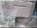
Ordnance Survey Cut Mark
This OS cut mark can be found on the south face of the tower of St Giles Church. It marks a point 93.399m above mean sea level.
Image: © Adrian Dust
Taken: 20 Nov 2015
0.01 miles
2
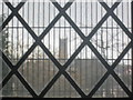
St. Laurence's Church (Ludlow | Viewed from St. Giles Church | Ludford)
Two churches from different places meet up with each other!
Image: © Fabian Musto
Taken: 19 Feb 2018
0.01 miles
3
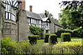
Ludford House
Large and ancient house next to the church, described by Pevsner as a 'picturesque group' whose building history was by no means clear
Image: © Philip Pankhurst
Taken: 18 May 2011
0.01 miles
4
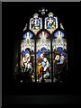
Magnificent stained glass window within St Giles, Ludford
Image: © Basher Eyre
Taken: 8 Aug 2009
0.01 miles
5
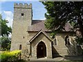
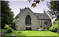
St Giles church, Ludford
A Grade II* listed https://historicengland.org.uk/listing/the-list/list-entry/1291747 parish church dating from the 11th century. The church is surrounded by almshouses and an old manor house and it feels like stepping through a time warp visiting this location, only the nearby sound of traffic reminds one that this is still the 21st century.
Image: © Philip Halling
Taken: 12 Jul 2018
0.01 miles
6
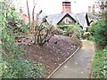
Ludford House, Charlton House garden
The lower garden of Charlton House the Northeast annexe of Ludford House. Immediately front and centre is the lodge, the 1835 gatehouse to the servants wing of Ludford House. On the left is a gable of Ludford Lodge, built circa 1841, a large house overlooking the river Teme. On the right, the roof and chimneys of the almshouse complex of St Giles.
Image: © Ralph Beardmore
Taken: Unknown
0.01 miles
7
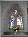
Floral display beneath a stained glass window at St Giles, Ludford
Image: © Basher Eyre
Taken: 8 Aug 2009
0.01 miles
10
St Giles, Ludford
The East end, showing the Fox chapel on the North side, added in 1555.
Image: © Philip Pankhurst
Taken: 18 May 2011
0.01 miles