IMAGES TAKEN NEAR TO
Sandpits Road, LUDLOW, SY8 1HL
Introduction
This page details the photographs taken nearby to Sandpits Road, SY8 1HL by members of the Geograph project.
The Geograph project started in 2005 with the aim of publishing, organising and preserving representative images for every square kilometre of Great Britain, Ireland and the Isle of Man.

There are currently over 7.5m images from over14,400 individuals and you can help contribute to the project by visiting https://www.geograph.org.uk
Image Map (Loading...)


Getting Data...Please wait
Leaflet Map data © OpenStreetMap
Images are licensed for reuse under creativecommons.org/licenses/by-sa/2.0
Notes
- Clicking on the map will re-center to the selected point.
- The higher the marker number, the further away the image location is from the centre of the postcode.
Image Listing (92 Images Found)
Images are licensed for reuse under creativecommons.org/licenses/by-sa/2.0
Image
Details
Distance
1

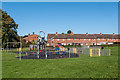
Wheeler Road multi use games area
Multi use games area on the Wheeler Road playing fields on the 1960s Sandpits Estate. The houses in the left background are on Whitbread Road and those in the right background are on Wheeler Road.
Image: © Ian Capper
Taken: 4 Oct 2010
0.03 miles
2
Wheeler Road play area
Play area off Wheeler Road on the 1960s Sandpits Estate. The houses in the background are on Whitbread Road.
Image: © Ian Capper
Taken: 4 Oct 2010
0.03 miles
3

Wheeler Road Playing Field
Once a football pitch, the field is now put to more diverse use with a skate park (its only a craze! 1976) and an indoor bowling alley.
Image: © Richard Webb
Taken: 14 Jan 2022
0.04 miles


6
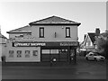
The Sandpits shop
At the junction of Livesey Avenue and Sandpits Road.
Image: © Richard Webb
Taken: 14 Jan 2022
0.05 miles
7

Wheeler Road Playing Field
Looking past the skate park towards Wheeler Road on the north side of the field.
Image: © Richard Webb
Taken: 14 Jan 2022
0.06 miles
8

Whitbread Road
From the junction with Sandpits Road. Pilot Officer Laurie Whitbread was shot down during The Battle of Britain 20th September 1940. He is buried in the nearby cemetery off Henley Road.
Image: © Richard Webb
Taken: 14 Jan 2022
0.07 miles
9

Whitbread Road
Pilot Officer Laurie Whitbread was shot down during The Battle of Britain 20th September 1940. He is buried in the nearby cemetery off Henley Road.
Image: © Richard Webb
Taken: 14 Jan 2022
0.07 miles
10
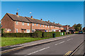
Whitbread Road
Housing on the 1960s Sandpits Estate.
Image: © Ian Capper
Taken: 4 Oct 2010
0.07 miles