IMAGES TAKEN NEAR TO
Coppice Drive, CRAVEN ARMS, SY7 9RH
Introduction
This page details the photographs taken nearby to Coppice Drive, SY7 9RH by members of the Geograph project.
The Geograph project started in 2005 with the aim of publishing, organising and preserving representative images for every square kilometre of Great Britain, Ireland and the Isle of Man.

There are currently over 7.5m images from over14,400 individuals and you can help contribute to the project by visiting https://www.geograph.org.uk
Image Map
Images are licensed for reuse under creativecommons.org/licenses/by-sa/2.0
Notes
- Clicking on the map will re-center to the selected point.
- The higher the marker number, the further away the image location is from the centre of the postcode.
Image Listing (114 Images Found)
Images are licensed for reuse under creativecommons.org/licenses/by-sa/2.0
Image
Details
Distance
1
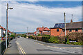
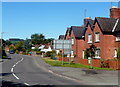
Greenfields Road
Road off Clun Road developed in the c.1930s/40s.
Image: © Ian Capper
Taken: 4 May 2023
0.08 miles
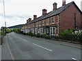
2
Albion Villas, Laurels and Pengwern
Early 20th Century houses on Clun Road.
Image: © Ian Capper
Taken: 4 May 2023
0.10 miles
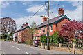
3
Milwaukee Terrace, Craven Arms
A row of terraced cottages on the road west out of town.
Image: © Richard Law
Taken: 3 Aug 2014
0.11 miles
4

The Crescent
Cul-de-sac (despite the name) off Greenfields Road developed in the c.1930s/40s.
Image: © Ian Capper
Taken: 4 May 2023
0.11 miles
5
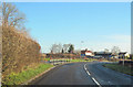
B4368 running into Craven Arms from the west
Image: © John Firth
Taken: 22 Dec 2011
0.12 miles
6
Clun Road, Craven Arms
Viewed from opposite the Brook Road junction looking west along the B4368 Clun Road.
Clun is 13km (8 miles) away.
Image: © Jaggery
Taken: 7 Sep 2012
0.13 miles
7

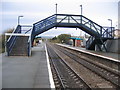
Central Wales Junction
Looking south towards Hereford from the end of Craven Arms Station. Craven Arms was simply a wayside inn before the coming of the railways in the mid 1800s. The town grew up as the railway developed as an important junction for traffic with mid-wales and Shropshire. The well known livestock markets grew and brought prosperity to the town. Today the single track Central Wales Line is a "basic railway" with 4 trains day. It leaves the main Hereford - Shrewsbury line at this simple junction before heading off into the hills to the right (west).
Image: © David Stowell
Taken: 14 Nov 2006
0.15 miles
8
Craven Arms Station
Looking south towards Hereford from the end of Craven Arms Station. Craven Arms was simply a wayside inn before the coming of the railways in the mid 1800s. The town grew up as the railway developed as an important junction for traffic with mid-wales and Shropshire. The well known livestock markets grew and brought prosperity to the town. Today the station is little more than a couple of bus shelters. It does seem to enjoy a reasonable train service to Hereford and Shrewsbury once again. In addition the station is the junction for the delightful Central Wales Line which has thankfully survived, albeit as a very basic railway, despite threats of closure over the years. The actual junction is in the next square at Image
Image: © David Stowell
Taken: 14 Nov 2006
0.16 miles
9
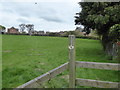
On part of the Shropshire Way in Craven Arms
Great to walk a section of the Shropshire Way that I have not walked before.
Image: © Jeremy Bolwell
Taken: 29 Apr 2018
0.17 miles
10
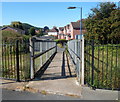
Exit from platform 1, Craven Arms railway station
Passengers have a choice of exits from, and entrances to, the station. This footpath connects platform 1 with Ash Close and adjacent residential streets.
The main entrance/exit is from platform 2, accessed from platform 1 via the station footbridge. http://www.geograph.org.uk/photo/3120210
Image: © Jaggery
Taken: 7 Sep 2012
0.17 miles