IMAGES TAKEN NEAR TO
Seifton Batch, CRAVEN ARMS, SY7 9LG
Introduction
This page details the photographs taken nearby to SY7 9LG by members of the Geograph project.
The Geograph project started in 2005 with the aim of publishing, organising and preserving representative images for every square kilometre of Great Britain, Ireland and the Isle of Man.

There are currently over 7.5m images from over14,400 individuals and you can help contribute to the project by visiting https://www.geograph.org.uk
Image Map
Images are licensed for reuse under creativecommons.org/licenses/by-sa/2.0
Notes
- Clicking on the map will re-center to the selected point.
- The higher the marker number, the further away the image location is from the centre of the postcode.
Image Listing (7 Images Found)
Images are licensed for reuse under creativecommons.org/licenses/by-sa/2.0
Image
Details
Distance
1
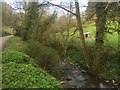
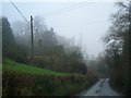
Brook, Seifton Batch
Draining the dip between the two limestone ridges around Westhope.
Image: © Richard Webb
Taken: 1 Apr 2019
0.03 miles
2
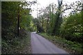
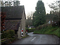
Road through Seifton Batch
Seifton Batch is a steep sided valley breaching one of the parallel limestone ridges.
Image: © Richard Webb
Taken: 20 Oct 2015
0.04 miles
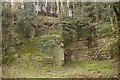
4
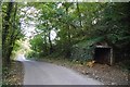
Garage, Seifton Batch
Beside a limestone quarry and almost hidden by ivy.
Image: © Richard Webb
Taken: 20 Oct 2015
0.08 miles