IMAGES TAKEN NEAR TO
Bache Mill, CRAVEN ARMS, SY7 9JX
Introduction
This page details the photographs taken nearby to Bache Mill, SY7 9JX by members of the Geograph project.
The Geograph project started in 2005 with the aim of publishing, organising and preserving representative images for every square kilometre of Great Britain, Ireland and the Isle of Man.

There are currently over 7.5m images from over14,400 individuals and you can help contribute to the project by visiting https://www.geograph.org.uk
Image Map
Images are licensed for reuse under creativecommons.org/licenses/by-sa/2.0
Notes
- Clicking on the map will re-center to the selected point.
- The higher the marker number, the further away the image location is from the centre of the postcode.
Image Listing (6 Images Found)
Images are licensed for reuse under creativecommons.org/licenses/by-sa/2.0
Image
Details
Distance
1
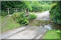
Ford at Diddlebury
This is one of two fords at Diddlebury.
Image: © John Walton
Taken: 1 Aug 2015
0.04 miles
2
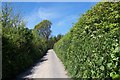
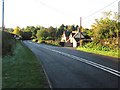
The road to Middlehope
...in a place called Bache Mill, near Diddlebury. There's lots of lanes like this in Shropshire: single-track with hedges higher than the car. They're great!
Image: © Adrian Bailey
Taken: 15 May 2005
0.05 miles
5
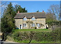
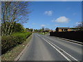
B4368, Diddlebury
Diddlebury is still occasionally pronounced "delbry". While still very much a present day, if fragmented village, this is almost one of the deserted villages of the Ludlow area, with a few houses near the church. Why were so many villages abandoned on the high ground above the Teme Valley? Both on the Clees and Bromyard uplands. A crash in the economics of wool production? Disease?
Another feature of the area is the number of motte and bailey earthworks.
Image: © Richard Webb
Taken: 24 Oct 2010
0.21 miles