IMAGES TAKEN NEAR TO
Balaams Heath, CRAVEN ARMS, SY7 9HH
Introduction
This page details the photographs taken nearby to Balaams Heath, SY7 9HH by members of the Geograph project.
The Geograph project started in 2005 with the aim of publishing, organising and preserving representative images for every square kilometre of Great Britain, Ireland and the Isle of Man.

There are currently over 7.5m images from over14,400 individuals and you can help contribute to the project by visiting https://www.geograph.org.uk
Image Map
Images are licensed for reuse under creativecommons.org/licenses/by-sa/2.0
Notes
- Clicking on the map will re-center to the selected point.
- The higher the marker number, the further away the image location is from the centre of the postcode.
Image Listing (5 Images Found)
Images are licensed for reuse under creativecommons.org/licenses/by-sa/2.0
Image
Details
Distance
1
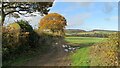
Field edge East of Beambridge, Corvedale
Looking NW along field edge East of Beambridge, Corvedale
Image: © Rob Bainbridge
Taken: 18 Nov 2017
0.14 miles
2
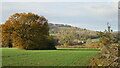
Looking over fields North of Baucott Farm
Looking over fields North of Baucott Farm, Beambridge in the background
Image: © Rob Bainbridge
Taken: 18 Nov 2017
0.16 miles
4
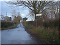
The lane between Beambridge and Broncroft
Image: © Andrew Longton
Taken: 6 Jul 2006
0.21 miles
5
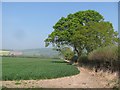
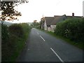
Oak, Balaam's Heath
A hedgerow oak tree in Corve Dale.
Image: © Richard Webb
Taken: 22 Apr 2011
0.24 miles