IMAGES TAKEN NEAR TO
Hungerford, CRAVEN ARMS, SY7 9HG
Introduction
This page details the photographs taken nearby to SY7 9HG by members of the Geograph project.
The Geograph project started in 2005 with the aim of publishing, organising and preserving representative images for every square kilometre of Great Britain, Ireland and the Isle of Man.

There are currently over 7.5m images from over14,400 individuals and you can help contribute to the project by visiting https://www.geograph.org.uk
Image Map
Images are licensed for reuse under creativecommons.org/licenses/by-sa/2.0
Notes
- Clicking on the map will re-center to the selected point.
- The higher the marker number, the further away the image location is from the centre of the postcode.
Image Listing (19 Images Found)
Images are licensed for reuse under creativecommons.org/licenses/by-sa/2.0
Image
Details
Distance
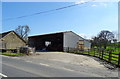
1
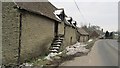
Malt House Farm, Hungerford
A stone building which has so far avoided being converted.
Image: © Richard Webb
Taken: 1 Apr 2013
0.01 miles
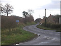
2
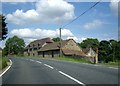
Roadside properties on the B4368 through Hungerford
Image: © Tom Pennington
Taken: 11 Aug 2007
0.04 miles

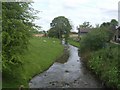
7
Hungerford Mill
The mill was powered by the River Corve.
Image: © John M
Taken: 2 May 2009
0.11 miles
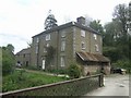
8
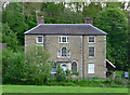
Hungerford Mill, Hungerford
Quite a grand late C18th front. Grade II listed.
Adjacent outbuildings are also listed (Image]).
Image: © Stephen Richards
Taken: 16 May 2014
0.11 miles