IMAGES TAKEN NEAR TO
Clee St. Margaret, CRAVEN ARMS, SY7 9EF
Introduction
This page details the photographs taken nearby to SY7 9EF by members of the Geograph project.
The Geograph project started in 2005 with the aim of publishing, organising and preserving representative images for every square kilometre of Great Britain, Ireland and the Isle of Man.

There are currently over 7.5m images from over14,400 individuals and you can help contribute to the project by visiting https://www.geograph.org.uk
Image Map
Images are licensed for reuse under creativecommons.org/licenses/by-sa/2.0
Notes
- Clicking on the map will re-center to the selected point.
- The higher the marker number, the further away the image location is from the centre of the postcode.
Image Listing (19 Images Found)
Images are licensed for reuse under creativecommons.org/licenses/by-sa/2.0
Image
Details
Distance
1
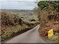
Lane descending towards Clee St Margaret
Image: © Mat Fascione
Taken: 30 Jan 2022
0.03 miles
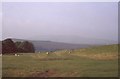
2

Clee Liberty
Common with evidence of bracken control. View past Welsh Mountain sheep (the traditional Clee breed) to Nordy Bank, a hill fort.
Image: © Richard Webb
Taken: 22 Oct 2010
0.05 miles
3
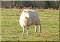
Clee Liberty Common sheep contemplates their next move
The extensive Clee Liberty Common has many sheep grazing there (so not a good place for dog walkers to visit). This local sheep has an important decision to make: (a) stay put (b) turn round and face another direction (c) resume grazing or (d) scuttle away.
Image: © P L Chadwick
Taken: 16 Jan 2008
0.06 miles
4
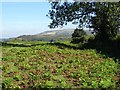
View to Brown Clee Hill
View to Brown Clee Hill from footpath on open access land to the south west.
Image: © Philip Halling
Taken: 20 Sep 2019
0.07 miles
6
Clee Liberty
Common land on Brown Clee Hill with a view towards Nordy Bank (hill fort) and a hazy Abdon Burf.
Image: © Richard Webb
Taken: Unknown
0.08 miles
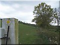
7

Unclassified road from Stokegorse to Clee St. Margaret
This narrow public road descends rapidly from its high point by the Clee Liberty Common car park, down to the village of Clee St. Margaret
Image: © P L Chadwick
Taken: 16 Jan 2008
0.09 miles
8
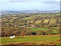
Shropshire countryside seen from Clee Liberty Common
On a rare Winter's day, when there is sunshine and no mist, the beautiful Shropshire countryside can be seen in this view taken from a bridleway on the common. The ubiquitous Shropshire sheep takes its rightful place in the scene as the county remains a stronghold of the sheep farming industry.
Image: © P L Chadwick
Taken: 16 Jan 2008
0.09 miles
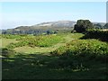
9

Clee Liberty Common
The top of Brown Clee appears just over the nearest brow. The 540-acre common is owned by Clee St. Margaret Parish Council.
Image: © Jonathan Billinger
Taken: 6 Dec 2007
0.09 miles
10
Common land below Brown Clee Hill
Footpath crossing common land below Brown Clee Hill which can be seen in the background.
Image: © Philip Halling
Taken: 20 Sep 2019
0.12 miles