IMAGES TAKEN NEAR TO
Corvedale Road, CRAVEN ARMS, SY7 9BU
Introduction
This page details the photographs taken nearby to Corvedale Road, SY7 9BU by members of the Geograph project.
The Geograph project started in 2005 with the aim of publishing, organising and preserving representative images for every square kilometre of Great Britain, Ireland and the Isle of Man.

There are currently over 7.5m images from over14,400 individuals and you can help contribute to the project by visiting https://www.geograph.org.uk
Image Map
Images are licensed for reuse under creativecommons.org/licenses/by-sa/2.0
Notes
- Clicking on the map will re-center to the selected point.
- The higher the marker number, the further away the image location is from the centre of the postcode.
Image Listing (6 Images Found)
Images are licensed for reuse under creativecommons.org/licenses/by-sa/2.0
Image
Details
Distance
1
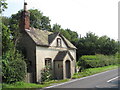
Old Toll House, Whettleton Pool
Toll House in the parish of Craven Arms, Toll Cottage, 131, Corvedale Road, SY7 9BU.
Grade II listed.
List Entry Number: 1269901 https://historicengland.org.uk/listing/the-list/list-entry/1269901
Surveyed
Milestone Society National ID: SA.CRA
Image: © Milestone Society
Taken: Unknown
0.05 miles
2
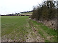
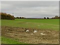
Fieldside footpath
This path east of Craven Arms is signposted as'Hills and Dales Hike'.
Image: © James Allan
Taken: 1 Apr 2016
0.08 miles
3
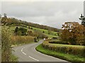
B4368, Whettleton
Just east of Craven Arms.
Image: © Richard Webb
Taken: 19 Nov 2021
0.12 miles
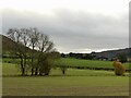
6
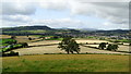
View towards Craven Arms & Stoke Wood from below Halford Wood
Image: © Colin Park
Taken: 20 Aug 2019
0.21 miles