IMAGES TAKEN NEAR TO
Newcastle, CRAVEN ARMS, SY7 8QY
Introduction
This page details the photographs taken nearby to SY7 8QY by members of the Geograph project.
The Geograph project started in 2005 with the aim of publishing, organising and preserving representative images for every square kilometre of Great Britain, Ireland and the Isle of Man.

There are currently over 7.5m images from over14,400 individuals and you can help contribute to the project by visiting https://www.geograph.org.uk
Image Map
Images are licensed for reuse under creativecommons.org/licenses/by-sa/2.0
Notes
- Clicking on the map will re-center to the selected point.
- The higher the marker number, the further away the image location is from the centre of the postcode.
Image Listing (2 Images Found)
Images are licensed for reuse under creativecommons.org/licenses/by-sa/2.0
Image
Details
Distance
1
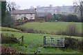
Folley Farm
The buildings of a sheep and cattle farm near Folly Brook. Folly/Folley - the spelling is obviously interchangeable.
Image: © Graham Horn
Taken: 21 Nov 2009
0.19 miles
2
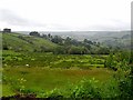
Fields near Stone House Farm
Looking across some rather poor grazing to Stone House Farm on the opposite ridge. The valley of the Folly Brook lies beyond.
Image: © Oliver Dixon
Taken: 14 Jun 2010
0.22 miles