IMAGES TAKEN NEAR TO
Newcastle, CRAVEN ARMS, SY7 8QS
Introduction
This page details the photographs taken nearby to SY7 8QS by members of the Geograph project.
The Geograph project started in 2005 with the aim of publishing, organising and preserving representative images for every square kilometre of Great Britain, Ireland and the Isle of Man.

There are currently over 7.5m images from over14,400 individuals and you can help contribute to the project by visiting https://www.geograph.org.uk
Image Map
Images are licensed for reuse under creativecommons.org/licenses/by-sa/2.0
Notes
- Clicking on the map will re-center to the selected point.
- The higher the marker number, the further away the image location is from the centre of the postcode.
Image Listing (7 Images Found)
Images are licensed for reuse under creativecommons.org/licenses/by-sa/2.0
Image
Details
Distance
1
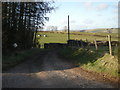
Ale Oak Farm
Although about 400 metres above sea level, the land is good pasture.
Image: © Oliver Dixon
Taken: 14 Jun 2010
0.02 miles
2
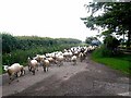
Sheep on the run, Ale Oak Farm
A large number of sheep being driven along the road by Land Rover and quad bike, ably assisted by a few dogs.
Image: © Oliver Dixon
Taken: 14 Jun 2010
0.04 miles
4
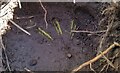
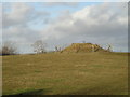
Ordnance Survey Rivet
This OS rivet can be found on a buried concrete block at the road junction. It marks a point 397.171m above mean sea level.
Image: © Adrian Dust
Taken: 21 Oct 2021
0.10 miles
5
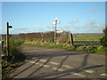
Someone is playing silly so-and-sos
A rather stupid person has turned the sign around so that it points into the adjacent field. Unfortunately this is a not an uncommon occurrence in the area.
Image: © Row17
Taken: 26 Feb 2008
0.11 miles
6
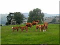
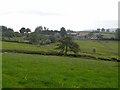
Cows and calves, Ale Oak Farm
Although about 400 metres above sea level, the land is good pasture. The Clun valley lies beyond.
Image: © Oliver Dixon
Taken: 14 Jun 2010
0.12 miles