IMAGES TAKEN NEAR TO
Newcastle, CRAVEN ARMS, SY7 8QJ
Introduction
This page details the photographs taken nearby to SY7 8QJ by members of the Geograph project.
The Geograph project started in 2005 with the aim of publishing, organising and preserving representative images for every square kilometre of Great Britain, Ireland and the Isle of Man.

There are currently over 7.5m images from over14,400 individuals and you can help contribute to the project by visiting https://www.geograph.org.uk
Image Map
Images are licensed for reuse under creativecommons.org/licenses/by-sa/2.0
Notes
- Clicking on the map will re-center to the selected point.
- The higher the marker number, the further away the image location is from the centre of the postcode.
Image Listing (64 Images Found)
Images are licensed for reuse under creativecommons.org/licenses/by-sa/2.0
Image
Details
Distance
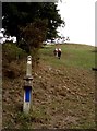
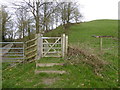
1
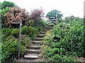
Steps on Offa's Dyke Path
Offa's Dyke path is a 285 Km long National Trail which roughly follows the Anglo-Welsh border. Over a third of its length, it runs along the 8th century Offa's Dyke earthworks (as here), seen climbing steps above the road at Bryndrinog.
Image: © Oliver Dixon
Taken: 14 Jun 2010
0.01 miles
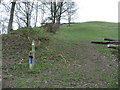
2
Offa's Dyke Path at Bryndrinog
Offa's Dyke path is a 285 Km long National Trail which roughly follows the Anglo-Welsh border. Over a third of its length, it runs along the 8th century Offa's Dyke earthworks (as here). Seen at Brydrinog at the top of the slope down to the River Clun.
Image: © Oliver Dixon
Taken: 14 Jun 2010
0.02 miles
3
Offa's Dyke Path at Bryndrinog
Offa's Dyke path is a 285 Km long National Trail which roughly follows the Anglo-Welsh border. Over a third of its length, it runs along the 8th century Offa's Dyke earthworks (as here), seen climbing the field above the Clun valley.
Image: © Oliver Dixon
Taken: 14 Jun 2010
0.02 miles
4
Cottage beside Offa's Dyke Path near Newcastle on Clun
It might be vacant and under renovation at the present time, but I've always thought what a good bed and breakfast establishment this could be, right next door to the path, so to speak....
Image: © Jeremy Bolwell
Taken: 23 Mar 2019
0.02 miles
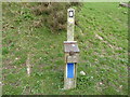
5
Walkers on Offa's Dyke Path
The walkers have just passed a track marker and water point on the steep hill above Wellfield on Offa's Dyke, the ancient boundary between England & Wales.
Image: © Alex Passmore
Taken: 15 Aug 2011
0.03 miles
6
Part of Offa's Dyke Path near Newcastle, Shropshire
A dauntingly steep section of the ODP for walkers walking the usual south to north route and a water tap is placed here in a little wooden box in a most thoughtful and caring manner. When I walked the path I was particularly grateful for the several such taps en route.
Image: © Jeremy Bolwell
Taken: 28 Feb 2012
0.03 miles
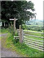
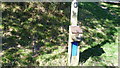
7
Severn Trent water tap on Offa's Dyke Path near Newcastle on Clun
I always stop and have a short drink.
Image: © Jeremy Bolwell
Taken: 23 Mar 2019
0.03 miles
8
Severn Trent drinking water tap on Offa's Dyke Path near Newcastle-on-Clun
The cold, crystal clear, refreshing drinking water here is quite simply the very best drinking water I have ever tasted, made more welcome by a hot August day on the ODP with a flask of coffee and a 500 ml water bottle already drunk, it was much, much needed. Thank you Severn Trent.
Image: © Jeremy Bolwell
Taken: 31 Aug 2014
0.04 miles
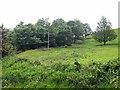
9
Part of Offa's Dyke Path and Offa's Dyke at Newcastle on Clun
Yes, the section with the water tap.
Image: © Jeremy Bolwell
Taken: 23 Mar 2019
0.04 miles
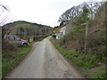
10
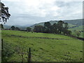
View in the Clun valley near Newcastle on Clun
A herd of cows and calves enjoy the autumn air.
Image: © Jeremy Bolwell
Taken: 16 Oct 2020
0.04 miles