IMAGES TAKEN NEAR TO
Newcastle, CRAVEN ARMS, SY7 8PN
Introduction
This page details the photographs taken nearby to SY7 8PN by members of the Geograph project.
The Geograph project started in 2005 with the aim of publishing, organising and preserving representative images for every square kilometre of Great Britain, Ireland and the Isle of Man.

There are currently over 7.5m images from over14,400 individuals and you can help contribute to the project by visiting https://www.geograph.org.uk
Image Map
Images are licensed for reuse under creativecommons.org/licenses/by-sa/2.0
Notes
- Clicking on the map will re-center to the selected point.
- The higher the marker number, the further away the image location is from the centre of the postcode.
Image Listing (4 Images Found)
Images are licensed for reuse under creativecommons.org/licenses/by-sa/2.0
Image
Details
Distance
1
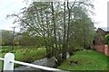
River Clun at Duffryn
The embroyonic river is crossed on a minor road by a flat bridge behind Duffryn Farm. The flood plain to the south-west is extensive; this is a river that can quickly rise.
Image: © Graham Horn
Taken: 21 Nov 2009
0.14 miles
2
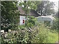
Semi-derelict roadside postbox
Almost five years to the day since this was last archived on Geograph (https://www.geograph.org.uk/photo/5032746), and it's looking shabbier still. A beguiling spot though, in the heart of the Clun Forest.
Image: © Mike Parker
Taken: 14 Jul 2021
0.15 miles
3
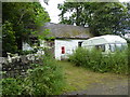
Old building by the roadside
With a post box. Lovely.
Image: © Jeremy Bolwell
Taken: 10 Jul 2016
0.16 miles
4
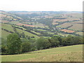
View up the Clun
Upper Clun Valley, around Newcastle.
Image: © Richard Webb
Taken: 3 Sep 2022
0.23 miles