IMAGES TAKEN NEAR TO
St. Thomas Close, CRAVEN ARMS, SY7 8LH
Introduction
This page details the photographs taken nearby to St. Thomas Close, SY7 8LH by members of the Geograph project.
The Geograph project started in 2005 with the aim of publishing, organising and preserving representative images for every square kilometre of Great Britain, Ireland and the Isle of Man.

There are currently over 7.5m images from over14,400 individuals and you can help contribute to the project by visiting https://www.geograph.org.uk
Image Map
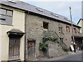
Images are licensed for reuse under creativecommons.org/licenses/by-sa/2.0
Notes
- Clicking on the map will re-center to the selected point.
- The higher the marker number, the further away the image location is from the centre of the postcode.
Image Listing (566 Images Found)
Images are licensed for reuse under creativecommons.org/licenses/by-sa/2.0
Image
Details
Distance
1
The Old Chapel (Clun)
Not much is known about this former chapel at Clun, but it is now a private house.
Image: © Fabian Musto
Taken: 21 Feb 2019
0.03 miles
2
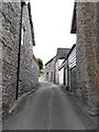
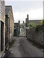
Kid Lane, Clun
One of several narrow lanes running north from the High Street. Kid Lane is opposite Bridge Street.
Image: © Penny Mayes
Taken: 15 Sep 2011
0.04 miles
3
Powells Lane, Clun
One of several narrow lanes that run north from the High Street.
Image: © Penny Mayes
Taken: 15 Sep 2011
0.04 miles
4
Location of Flush Bracket OSBM 11662: Clun, Museum
Image: © thejackrustles
Taken: 26 Mar 2017
0.05 miles
5
![Clun houses [12]](https://s1.geograph.org.uk/geophotos/06/98/23/6982305_4f5d2ca0_120x120.jpg)
Clun houses [12]
This Wesleyan Methodist Chapel in Newport Street was built in 1839, rebuilt in 1899 and converted in a private house in 1976.
The small town of Clun is astride the River Clun in the Shropshire Hills Area of Outstanding Natural Beauty. It is located some 14 miles northwest of Ludlow and some 5½ miles north of Knighton. There is evidence of settlement in the Neolithic period but the town grew around the site of an Anglo-Saxon church. The Normans built a castle and a new town was laid out, the grid plan of which survives in this tranquil valley.
Image: © Michael Dibb
Taken: 2 Jun 2021
0.05 miles
6

Clun Town Hall and Museum
Clun Museum was opened in the Town Hall over 70 years ago and houses a collection of prehistoric tools dating as far back as 4000 years.
Image: © Jeff Buck
Taken: 16 Jul 2006
0.05 miles
7
The Maltings Tea Shop
Above the shop is a workshop used by a wood carver. He was involved in the restoration work after the fire at Windsor Castle. There is a very neat example of his carving just above the tea shop entrance door.
Image: © Carol Walker
Taken: 15 Nov 2013
0.05 miles
8
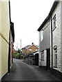
Looking down Kid Lane to High Street, Clun
Image: © Carol Walker
Taken: 15 Nov 2013
0.05 miles
9
![Clun buildings [8]](https://s2.geograph.org.uk/geophotos/06/98/33/6983398_63c88e9d_120x120.jpg)
Clun buildings [8]
Harpton House and adjoining shop, number 2 The Square, is early or mid 19th century, incorporating an earlier structure. Constructed of coursed rubble stone under a slate roof. Listed, grade II, with details at: https://historicengland.org.uk/listing/the-list/list-entry/1308104
The small town of Clun is astride the River Clun in the Shropshire Hills Area of Outstanding Natural Beauty. It is located some 14 miles northwest of Ludlow and some 5½ miles north of Knighton. There is evidence of settlement in the Neolithic period but the town grew around the site of an Anglo-Saxon church. The Normans built a castle and a new town was laid out, the grid plan of which survives in this tranquil valley.
Image: © Michael Dibb
Taken: 2 Jun 2021
0.05 miles
10
![Clun houses [16]](https://s3.geograph.org.uk/geophotos/06/98/33/6983351_a94a9e71_120x120.jpg)
Clun houses [16]
Number 14 High Street is a late 17th century house which has been remodelled and extended in the early 19th century and altered in the 20th century. Constructed of coursed rubble stone, rendered, under a slate roof. Listed, grade II, with details at: https://historicengland.org.uk/listing/the-list/list-entry/1367251
The small town of Clun is astride the River Clun in the Shropshire Hills Area of Outstanding Natural Beauty. It is located some 14 miles northwest of Ludlow and some 5½ miles north of Knighton. There is evidence of settlement in the Neolithic period but the town grew around the site of an Anglo-Saxon church. The Normans built a castle and a new town was laid out, the grid plan of which survives in this tranquil valley.
Image: © Michael Dibb
Taken: 2 Jun 2021
0.06 miles