IMAGES TAKEN NEAR TO
Asterton, LYDBURY NORTH, SY7 8BJ
Introduction
This page details the photographs taken nearby to SY7 8BJ by members of the Geograph project.
The Geograph project started in 2005 with the aim of publishing, organising and preserving representative images for every square kilometre of Great Britain, Ireland and the Isle of Man.

There are currently over 7.5m images from over14,400 individuals and you can help contribute to the project by visiting https://www.geograph.org.uk
Image Map
Images are licensed for reuse under creativecommons.org/licenses/by-sa/2.0
Notes
- Clicking on the map will re-center to the selected point.
- The higher the marker number, the further away the image location is from the centre of the postcode.
Image Listing (6 Images Found)
Images are licensed for reuse under creativecommons.org/licenses/by-sa/2.0
Image
Details
Distance
1
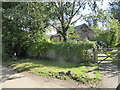
Grove Cottage
Isolated rural dwelling.
Image: © Jeremy Bolwell
Taken: 29 Aug 2016
0.00 miles
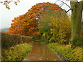
2
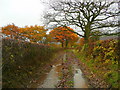
Lane from Barnes Farm 3
Nearing the Asterton road, the lane is converted into a stream on this wet November day.
Oaks are in full colour.
Image: © Jonathan Billinger
Taken: 13 Nov 2008
0.19 miles
3
Un-named lane crosses the Criftin Brook
Image: © Stuart Logan
Taken: 21 Sep 2013
0.20 miles
4
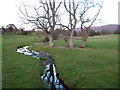
Stream and reflection
Looking from the bridge, upstream at the reflection of the trees.
Image: © John Poyser
Taken: 12 Nov 2007
0.21 miles
5

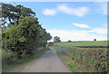
Lane junction
Quiet lanes on a summer afternoon.
Image: © Jeremy Bolwell
Taken: 29 Aug 2016
0.22 miles
6
Lane from Barnes Farm 2
At this point it is more like a canal!
Rain is falling in heavy drops on this November morning.
Image: © Jonathan Billinger
Taken: 13 Nov 2008
0.23 miles